Saudi Arabia | Snow expected in the north and rain expected in Hafar Al-Batin, Riyadh and Dammam within the next 24 hours
Update | Wednesday 2/17/2021 at 2:00 pm
Weather of Arabia - Sinan Khalaf - the Kingdom will be affected in the coming hours, God willing, by the eruption of a very cold air mass of polar origin that affects the Levant region and the eastern basin of the Mediterranean Sea, carrying with it heavy rains and heavy snow to parts of Jordan, Palestine and Syria, and it will work to create unstable weather conditions In many regions of the Kingdom, it varies between showers of rain and snow in the far northern heights of the Kingdom, in addition to active winds and dust.
If you are browsing from the phone, you can download the new ArabiaWeather application that provides accurate weather forecasts for thousands of regions in the Kingdom. Press here.
Wednesday / Thursday night
Possibly snow on Turaif, Qurayyat, and Tabuk heights
Our latest weather forecasts in Arab weather indicate that there are high opportunities, which are considered the first of their kind for this year, for snowfall in both Tarif and Qurayyat, in conjunction with the passage of the polar air mass into the region's airspace from Wednesday evening, and continue at intervals until Thursday morning, accompanied by temperatures Very low, close to zero percent, and it is expected that this snow will sometimes accumulate in the mentioned areas.
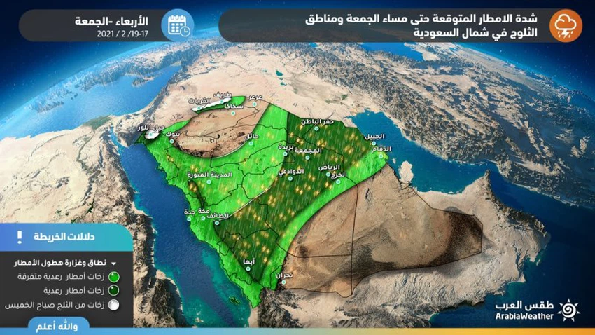
The capital will reach Riyadh and Dammam
Areas covered expect rainy Wednesday and Thursday
In conjunction with the crossing of a cold air front across the region’s atmosphere with the evening hours on Wednesday, a belt of rainy clouds is forming from the north of Hafar Al-Batin area up to the southern parts of Jeddah, and this belt moves quickly with the hours of the night to affect Hafar Al-Batin with moderate intensity, then the Qassim region until Al-Taaf and Al-Baha, but weakly, and with the hours of dawn and morning on Thursday, the rain belt moves towards the south to affect the northern parts of the Riyadh region, and the entire coasts of the eastern region, including the cities of Dammam and Riyadh, in the form of sporadic showers with weak to medium intensity.
This weather condition requires warning from:
1- The danger of slipping on the roads when the rains start
2- The wind blowing through the cold air front crossing the region's airspace
3- Low visibility due to dust and raised dust
Browse on the official website