From memory.. Cyclone Nilufer, which drifted from the coasts of the Sultanate of Oman to the Indian coasts
Arab Weather - On these days in 2014, the Arabian Sea witnessed an accelerated development of a region of low atmospheric pressure in the middle of the Arabian Sea to the point of a hurricane to run along the eastern coasts of the Sultanate of Oman, and then move away from the Sultanate’s atmosphere to cast a shadow on the Indian coasts, leaving heavy rain and floods in those days. Regions.
If you are browsing from your phone, you can download the Arab Weather application, which provides accurate weather forecasts for thousands of regions, click here.
Cyclone Nilufer has reached Category 4
Deviated from the coasts of the Sultanate of Oman to the Indian coasts
In details, a region of low atmospheric pressure was formed in the middle of the Arabian Sea moving to the north of it on the twenty-sixth of October 2014, and witnessed a remarkable development of a tropical storm. These names fall within the scope of the Arabian Sea and Bay of Bengal scheduled by the World Organization.
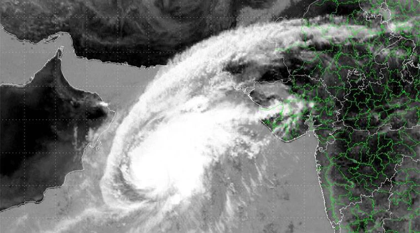
The tropical system continued to evolve to reach the cyclone, coinciding with its movement in the northwest direction towards the coasts of the Sultanate, to reach its peak with the early morning hours of Tuesday 28/10/2014. It reached the fourth degree within a few hours above the surface of the warm waters of the Arabian Sea, which exceeded 31 degrees Celsius, as these weather conditions provided a fertile environment for the development of the tropical state of Nilufer.
As Cyclone Nilofar moved along the coasts of the Sultanate, it had indirect effects of rain of varying intensity, high speed winds, and a great increase in sea waves on the coastal areas, to deviate gradually to the northeastern direction towards the Indian coasts, coinciding with the gradual decline of its strength to fade on October 31 over Gujarat Bay.
Read also:
Browse on the official website