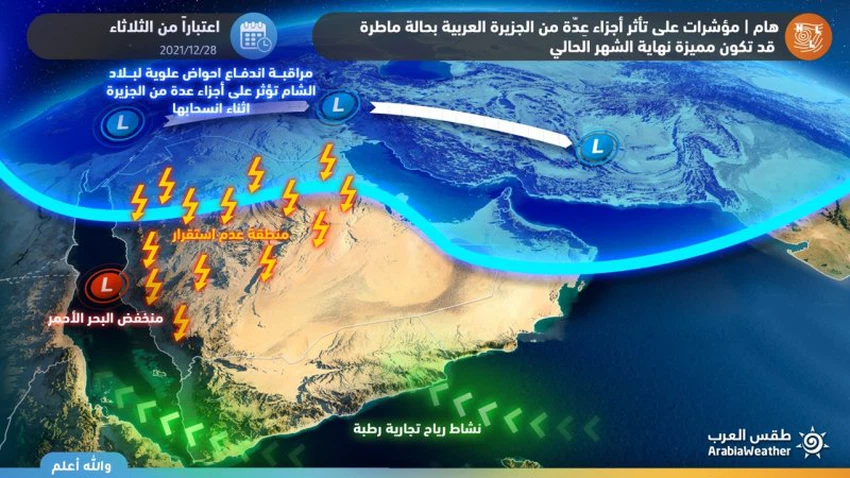
important | Under surveillance - drastic changes are expected in the air systems, and Saudi Arabia may enter a large wave of rain at the end of December and early January
Arab Weather - Sinan Khalaf - The weather forecast staff in Arab weather monitors the presence of initial indications of radical changes in the weather systems for the benefit of the Arabian Peninsula and Saudi Arabia in particular. And the most comprehensive since the start of the season, according to current indicators.
Preliminary features of the expected rainy condition
Thunder clouds, rain and dust waves in large areas
According to the latest weather data, it is expected that the rainy situation expected to affect the Kingdom will include most areas, in the form of thunderstorms that affect wide areas from the north, west, central and eastern parts of the Kingdom, accompanied by moderate and heavy thunderstorms and sometimes heavy hail, with a high chance of the formation of torrents and the flow of valleys. .
Arab Weather notes, however, that it is not possible to finalize the details of the expected weather situation during the last days of December and the beginning of January, due to the relatively long period and the wide margin of error from now on, and Arab Weather will issue reports and forecasts according to the latest developments.
For details of the weather around you, download the Arab Weather app from here

This type of cumulus thunderstorm clouds at this time of the year is often accompanied by the formation of descending air currents, which create dust waves and possibly local sand storms in the affected areas, causing a noticeable decrease in the horizontal visibility and sometimes its absence.
Radical changes to the air systems
This state of atmospheric turbulence comes as a result of high atmospheric pressure in important areas of the European continent and the pole, which will allow the cold upper basins to rush towards the eastern Mediterranean and the Arabian Gulf region and deepen them in the atmosphere of the region, coinciding with the blowing of warm and humid air currents from subtropical widths, and a superficial response to the depression The Red Sea clearly and effectively, which creates severe weather disturbances, creates a state of atmospheric instability, resulting in the formation of strong clouds accompanied by heavy thunderstorms.
Important recent topics:
Riyadh | Big fluctuation in temperatures at the end of the week and limited chances of rain
Browse on the official website