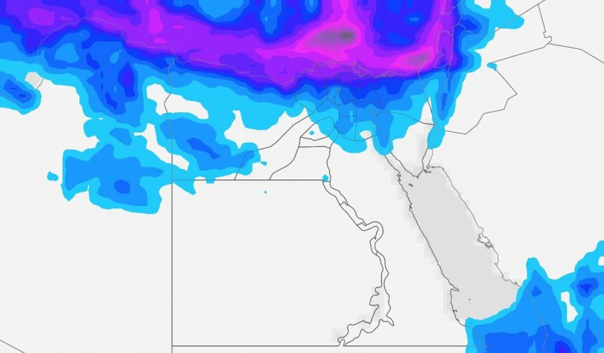
Heavy thunderstorms with chances of high water levels and torrents forming on the northern coasts, especially Alexandria and Rashid

Heavy thunderstorms with chances of high water levels and torrents forming on the northern coasts, especially Alexandria and Rashid
Meteorologist: Antonios Mekhiel
Expected weather during Wednesday and Thursday:
Significant decrease in temperature:
A marked decrease in temperatures in most regions of the republic, where mild to relatively cold weather prevails in the Delta and Cairo with temperatures ranging between 20-21 Celsius and relatively cold on the coasts of 18-19 Celsius, while it is moderate in the rest of the regions with temperatures of 23-25 Celsius and cool at night at all Regions.
A cold upper basin with a high-efficiency depression in the northeast:
Heavy rains on the northern Egyptian coasts, where the water level is expected to rise, and torrents form water bodies, especially in the cities of Alexandria and Rasheed, and the thunderstorms extend gradually to affect the rest of the delta areas, Cairo, the canal cities, North and Central Sinai, and may extend to include parts of northern Upper Egypt. The rains during Thursday will be concentrated on the northern coasts and the northern delta, as the opportunity is created for showers of rain on Halayeb and Shalateen, and the country is affected by a cold upper basin accompanied by a strong extension of the Red Sea depression over the north of the country, which creates an air depression in the eastern Mediterranean that moves gradually towards the peninsula in addition to movement And the activity of the postpartum flow towards the center and south of the country, which increases the air activities.
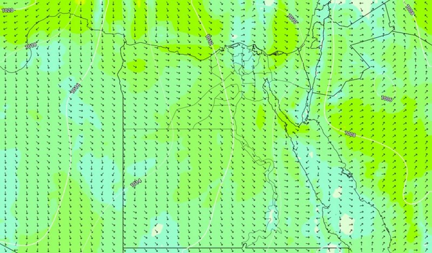
Active winds accompanied by the formation of thunderstorms that may cause dust locally:
Moderate to active northwesterly winds in most regions, with opportunities for wind activity with the formation of thunderstorms.
High waves and sea turbulence off the northern coasts:
As a result of the unstable weather conditions, waves are expected to rise during Wednesday and Thursday with heavy rains, especially in Alexandria. Please pay attention and limit marine activities, while the weather will be partially affected in the northern Red Sea and the Suez Canal due to the expected thunderstorms and are stable in the rest of the regions.
Alerts:
1- Stay away from low places and low residential and commercial floors.
2 - Stay away from electrical energy sources.
3- Fishermen are kindly requested to limit activities off the northern coasts and to take caution and caution.


Arabia Weather App
Download the app to receive weather notifications and more..