كميات الهطول المطري حتى الساعة 4:30 عصر اليوم الخميس 14-3-2019

2019-03-14 2019-03-14T14:41:29Z
أريج الدجاني
أريج الدجاني
محرر أخبار جوية - قسم التواصل الاجتماعي

طقس العرب - تأثرت المملكة بمنخفض جوي من الدرجة الثانية بحسب تصنيف طقس العرب لشدة المنخفضات الجوية، عمل على  تساقط الأمطار خاصة في شمال ووسط المملكة، كما رافقها  انخفاض شديد على  درجات الحرارة وتشكل الضباب  في المرتفعات.

وتالياً كميات الأمطار الهاطلة حتى الساعة 4:30 عصر اليوم الخميس 14-3-2019 بحسب محطات طقس العرب المتوفرة.


كميات الهطول الم


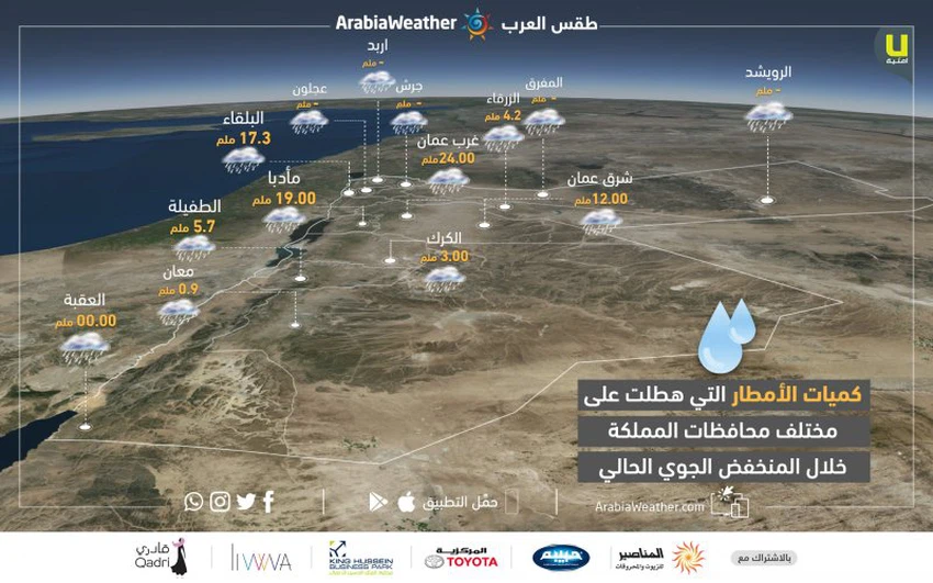
حيث سجلت المحطات القيم التالية: 

  • البلقاء: 17.3 ملم
  • الزرقاء: 4.2 ملم
  • غرب عمان: 24 ملم
  • شرق عمان: 12 ملم
  • الكرك: 3 ملم
  • مأدبا: 19 ملم
  • الطفيلة: 5.7 ملم
  • معان: 0.9 ملم


This article was written originally in Arabic and is translated using a 3rd party automated service. ArabiaWeather is not responsible for any grammatical errors whatsoever.
Plus
Related News
The heat dome warns of temperatures exceeding 50 degrees Celsius in five Arab countries in the coming days.

The heat dome warns of temperatures exceeding 50 degrees Celsius in five Arab countries in the coming days.

Relatively hot weather will return to the Kingdom again starting in the middle of the week.

Relatively hot weather will return to the Kingdom again starting in the middle of the week.

Mid-June without heat waves. Do indicators indicate a continued absence of heat waves in the second half?

Mid-June without heat waves. Do indicators indicate a continued absence of heat waves in the second half?

A potential eastern wave could affect several countries in the Arabian Peninsula at the end of June. What is an eastern wave?

A potential eastern wave could affect several countries in the Arabian Peninsula at the end of June. What is an eastern wave?