Jordan | February 2021 is characterized by many sharp fluctuations and great variation in the weather from one period to the next. Details and video
Jordan | February 2021: a month marked by many sharp fluctuations and great variation in the weather from one period to the next
Note: It is strictly forbidden to transmit this information, data and the obligatory brochure and publish it on social media and other means and / or dispose of it in any way without taking the prior and written consent of ArabiaWeather, under penalty of legal accountability.
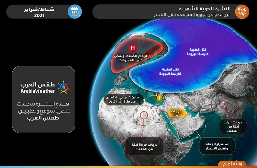
The most prominent expected weather phenomena:
General situation:
-
The month of February, God willing, will be marked by many sharp and many fluctuations and great variation in the weather from one period to another.
-
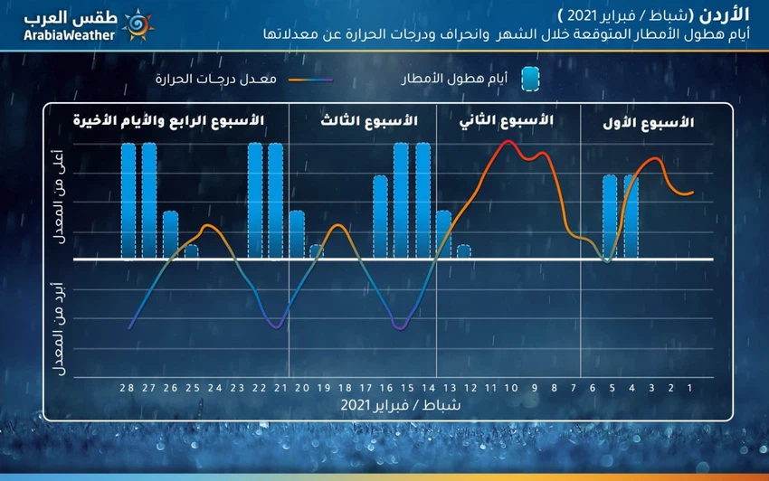
The month in its first part is characterized by higher than normal temperatures and little rain.
-
Rainfall performance improved after the middle of the month, as indicators indicate that the Kingdom will be affected by three major depressions, starting from the end of the second week of the month.
-
The chances of torrential formation increased several times due to the nature of the conditions that are associated with the fluctuations of the weather systems, which in turn impose high atmospheric instability that leads to thunderstorms.
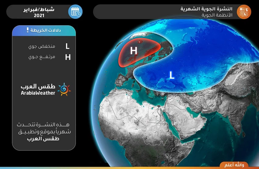
Expected weather systems:
28 day daily forecast | Rainfall days and temperature behavior:
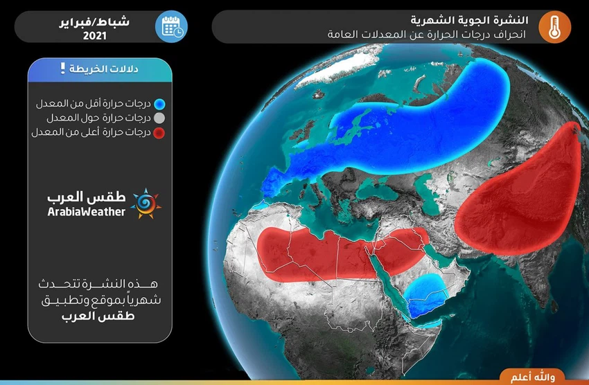
Temperature deviation from the general monthly averages:
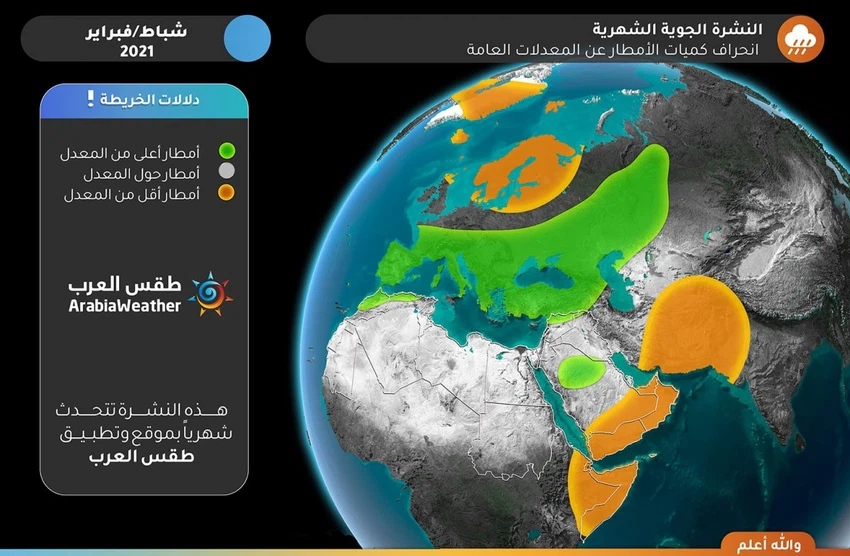
Rainfall deviation from the general monthly averages:
Detailed weather condition:
First week (1-7) February 2021:
- Rain
- On average.
- Temperatures
- Warmer than the rates.
- Torrents opportunity
- High.
- Snow opportunity
- There is no.
- Description of air systems
- The Kingdom is affected by extension of what is called the Red Sea Trough , which in turn brings rise to the temperature and atmosphere stable. At the end of the week an air depression advances in the middle and high air layers and coincides with the extension of the depression (the Red Sea Depression), which leads to the emergence of a regional state of air instability that is expected to affect Jordan so that thunderstorms are expected, God willing, on Thursday and Friday Different areas may lead to the formation of flash floods in some areas as a result of their abundance in narrow geographical areas.
Second week (8-14) February 2021:
- Rain
- Lower than the rates.
- Temperatures
- Warmer than the rates.
- Torrents opportunity
- Low.
- Snow opportunity
- Low.
- Description of air systems
- The Levant and Jordan are affected by warm air currents, so that the temperatures are warmer than usual in most regions, with poor chances of rain in general. At the end of the period, there are indications that the Levant, including Jordan, will be affected by an air depression that is believed to be classified at that time as advanced degrees, which breaks the stability and warmth of the weather and brings with it abundant rains and a significant drop in temperatures and a return to the opportunities for snowfall over the high mountain heights throughout the Levant.
Third week (15-21) February 2021:
- Rain
- About the higher rates.
- Temperatures
- About to colder than rates.
- Torrents opportunity
- Medium.
- Snow opportunity
- High on the high mountain heights in the Levant.
- Description of air systems
- It is expected to be a radical change in the system so that the air is expected to be affected by the Levant including Jordan this week , one in Bmnkhvdan Gueyen beginning of the period and the other at the end of Mata applicants bring with them two classifications of rain and low temperatures and snow opportunities over high mountain heights.
The fourth week and the last days of the month (22-28) February 2021:
- Rain
- Converted to higher rates.
- Temperatures
- About to colder than rates.
- Torrents opportunity
- Medium.
- Snow opportunity
- High on the high mountain heights in the Levant.
- Description of air systems
- The indicators for this week are visible until the time of the bulletin's release, when the weather is expected to be highly volatile and vary from one period to another. It is believed that there will be stability following the impact of the indicated low air in the (third) week preceding this week. This is followed by the high chances of exposure of the eastern Mediterranean and the Levant, including Jordan, with an air activity in the form of an air depression in the middle of this period with cold and rainy climates, and the weather before and after this activity is generally stable.
Climate situation (for professionals and interested parties):
The atmospheric system in the northern hemisphere continues to suffer from major consequences due to the occurrence of the so-called Sudden stratospheric warming, which occurs at an altitude of approximately 30 km above the surface of the Earth, specifically above the Arctic Circle, which occurred in early January / January 2021, where a radical change occurred in the shape of the weather patterns prevailing in the winter season in the northern hemisphere in addition to a direct impact on the so-called polar vortex (Polar Vortex) from which the winter weather depressions branched out with its rainy and snowy parts on the continents of the northern hemisphere . This polar vortex is coherent in its natural position over the North Pole and has branches in several regions and is responsible, after God's will, for the development of deep atmospheric depressions, but at this time, due to the stratospheric warming, it lost its cohesion greatly.
The shape of the polar vortex this year is strange and unusual, as many polar regions, the most important of which is Greenland, are suffering in the absence of deep polar depressions as usual, in addition to the fact that parts of central and eastern Canada suffer from unprecedented warming and a shortage of polar depressions. The usual deep, however, numerical and computational models are beginning to sense that there is a timid and potential recovery of the polar vortex on its way to occur in some parts of the Arctic Circle after the middle of 2 months.
The consequences of the sudden stratospheric warming that occurred earlier in January of the year 2021 on weather patterns and the polar vortex have become understandable in how they affect the weather in the Arab world, so there is no doubt that the current winter is considered one of the driest seasons in parts of The Arabian Gulf and the Sultanate of Oman for several years, and rainy conditions that are spaced in time and geography in the rest of the Arabian Peninsula, and regular second-class depressions in the Levant, separated by warm waves that resulted in great variation in temperatures from one period to another, and immature air depressions. Significantly, in the Maghreb, separated by record waves of warmth, especially in Libya and Tunisia, and it has become clear that the same weather patterns will continue until the end of the current winter, and God Almighty knows best.
And in view of some other factors in the atmosphere of those interested that contribute to the crystallization of the atmosphere, computer modeling projections indicate that the coefficients of fluctuations in February of 2021 will be as follows:
- North Atlantic Coefficient (NAO): the negative phase most days of the month, but indications are that it will approach the neutral phase in the second part of the month.
- The effect of the main parameter statistically at this stage alone (without taking the rest of the coefficients) with a correlation coefficient of more than 90% is: temperatures significantly cooler than usual throughout the European continent, and warmer than usual throughout the Arab world.
- Arctic Oscillation Coefficient (AO): The negative phase most days of the month, but indications are moving that it will approach the neutral phase at the end of the month.
- The effect of the main parameter statistically at this stage alone (without taking the rest of the coefficients) with a correlation coefficient of more than 90% is: temperatures significantly cooler than usual throughout the European continent, and warmer than usual throughout the Arab world.
- Northern Atlantic water surface temperature coefficient (AMO): significantly positive .
- The effect of the main parameter statistically at this stage alone (without taking the rest of the coefficients) with a correlation coefficient of more than 90% is: Temperatures warmer than usual in the Levant.
- The laninia phenomenon: the negative phase of weak to moderate intensity.
- The effect of the main parameter statistically at this stage alone (without taking the rest of the coefficients) with a correlation factor of more than 90% is: There is no effect within the specified correlation parameter.
- Pacific Northern Water Surface Temperature Oscillation Coefficient (PDO): negative phase.
- The effect of the main parameter statistically at this stage alone (without taking the rest of the coefficients) with a correlation coefficient of more than 90% is: Temperatures slightly cooler than usual in the Levant.
God knows
Arabia Weather App
Download the app to receive weather notifications and more..
