الأردن | كميات الهطول المطري حتى الساعة 10:00 صباح اليوم الإثنين 25-3-2019
2019-03-25
2019-03-25T10:43:08Z

طقس العرب - تأثرت المملكة اعتباراً من ساعات مساء الأحد وحتى اليوم الإثنين بمنخفض جوي من الدرجة الثانية عمل على هطول الأمطار وزخات البرد كما وأدى إلى تساقط الثلوج في جبال الجنوب العالية.
وتالياً كميات الهطول المطري حتى الساعة العاشرة من صباح اليوم الإثنين 25-3-2019 بحسب محطات طقس العرب المتوفرة.
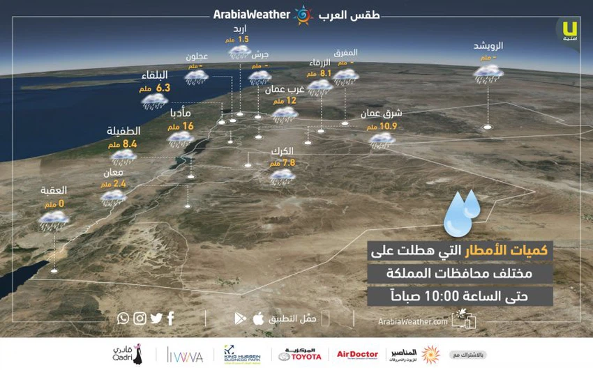
حيث سجلت المحطات القيم التالية:
- إربد: 1.5 ملم
- البلقاء: 6.3 ملم
- الزرقاء: 8.1
- شرق عمان: 10.9 ملم
- غرب عمان: 12 ملم
- الكرك: 7.8 ملم
- مادبا: 16 ملم
- الطفيلة: 8.4 ملم
- معان: 2.4 ملم
تابع تحديثات المنخفض الجوي أول بأول عبر موقع وتطبيق طقس العرب
This article was written originally in Arabic and is translated using a 3rd party automated service. ArabiaWeather is not responsible for any grammatical errors whatsoever.


Arabia Weather App
Download the app to receive weather notifications and more..