الأرصاد العمانية تُحدد المسار الأكثر ترجيحاً لإعصار كيار في بحر العرب

2019-10-28 2019-10-28T14:29:23Z
سنان خلف
سنان خلف
محرر أخبار جوية- قسم التواصل الاجتماعي

طقس العرب - نشرت الهيئة العامة للأرصاد الجوية في سلطنة عُمان عبر حسابها في تويتر خريطة توضح المسار الذي يتوقع ان يسلكه اعصار كيار المتواجد حالياً في بحر العرب، والذي لازال يُصنف ضمن الدرجة الرابعة على سلم الاعاصير.


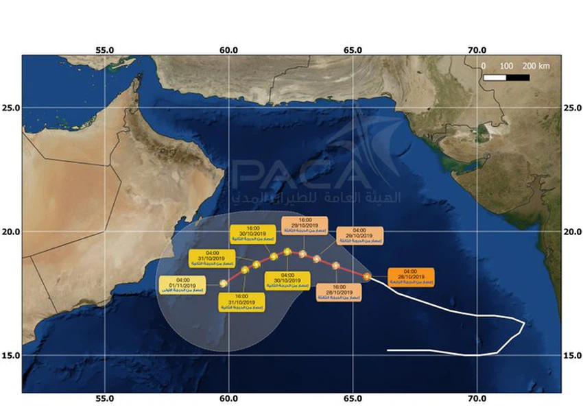
المسار المُتوقع لإعصار كيار في بحر العرب 


وبحسب هذا المسار فيُتوقع أن يتحرك اعصار كيار نحو الغرب والشمال الغربي، باتجاه سواحل سلطنة عمان خلال الـ 48 ساعة القادمة، وذلك مع تراجع تدريجي في قوته، ليتحرك لاحقاً نحو الاتجاه الجنوب الغربي محاذيا لسواحل محافظات جنوب الشرقية والوسطى وظفار، وسيبعد مركزه عن راس مدركة 200 كم، مع استبعاد عبور عين اعصار كيار لسواحل السلطنة. 


وبحسب التقرير الصادر عن هيئة الأرصاد الجوية فيُتوقع أن تبدأ التأثيرات غير المباشرة لإعصار كيار اعتباراً من مساء الثلاثاء، إذ يُتوقع تدفق سُحب رعدية نحو المنطقة تعمل على تساقط الامطار، وتترافق بنشاط لافت للرياح. 


This article was written originally in Arabic and is translated using a 3rd party automated service. ArabiaWeather is not responsible for any grammatical errors whatsoever.
See More
Related News
The tropical system in the Arabian Sea is moving northward, away from the southern Arabian Peninsula.

The tropical system in the Arabian Sea is moving northward, away from the southern Arabian Peninsula.

Arabian Gulf: Ramadan comes in the winter, away from the scorching summer heat.

Arabian Gulf: Ramadan comes in the winter, away from the scorching summer heat.

New updates issued for the tropical depression in the Arabian Sea

New updates issued for the tropical depression in the Arabian Sea

In a significant development, the US GFS model predicts the formation of a tropical cyclone in the Arabian Sea.

In a significant development, the US GFS model predicts the formation of a tropical cyclone in the Arabian Sea.