The Arab-European Model | Tropical turbulence in the Arabian Sea could turn into a hurricane and driven by it, so Oman is possible
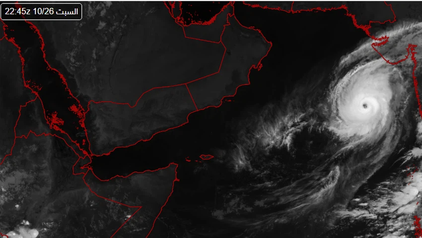
Arab Weather - Sinan Khalaf - a new tropical turmoil that began to collect numerical models in the Arabian Sea during the next week, some of which began to explicitly refer to its development and transformation into a tropical cyclone moving towards the coast of the Sultanate of Oman , while others are still referred to as a tropical turbulence or a tropical storm.
The Arab-European model:
Tropical turbulence in the Arabian Sea could turn into a hurricane
The European numerical model, according to its latest update this morning, Tuesday, October 13, 2020, indicates the rush of a tropical wet wave from the Bay of Bengal westward towards the coast of eastern India, where a state of air instability was formed there and developed into tropical disturbance within Indian lands.

In the coming hours, it is expected that this tropical turbulence will move west across the Indian land towards the Arabian Sea during the next two days, to turn according to the European numerical model for a tropical storm , and then a tropical cyclone will move later towards the Sultanate of Oman.
Important satellite link for monitoring orbital disturbances in the Arabian Sea from here

This is what the rest of the numerical models indicate
As for the rest of the numerical models, they are semi-assembled to form a tropical state in the Arabian Sea , but until now it is not clear in its expected intensity or path, and the extent of its potential impact on the southern coasts of the Arabian Peninsula and the Sultanate of Oman, which means that the overall projections indicate a tropical state in The Arabian Sea, but it is so far not clear in terms of strength and path, and Weather will follow up continuously and issue updates about the weather in the Arabian Sea first hand.
Previous tropical cases and hurricanes formed in the Arabian Sea during October
It is noteworthy that the month of October is considered one of the active periods in which tropical states are active in the Arabian Sea , and the climate archive is full of many of these cases, some of which turned into cyclones that later moved towards the Sultanate of Oman, most notably Cyclone Kiar and Cyclone Laban.
More details about the increasing opportunities for tropical conditions in the Arabian Sea can be found in the monthly newsletter via the Arab Weather app


Arabia Weather App
Download the app to receive weather notifications and more..