Classified as unseasonal, a polar air mass is rushing into central and eastern Europe, causing a severe cold wave laden with snow (details)
")
Arab Weather - Weather experts at the Arab Weather Regional Center are monitoring the latest developments in weather systems in the Northern Hemisphere. Computer simulations indicate that an extremely cold air mass, unusual for this time of year and characterized by polar characteristics, is arriving in central and eastern Europe, bringing with it bitterly cold weather and snowfall in many areas.
A massive, extremely cold air mass is pushing towards central and eastern Europe and will continue until the beginning of next week.
In detail, experts indicated that as a result of the formation of a strong high pressure system across large areas of western and central Europe, the polar jet stream is undulating, and an extremely cold, polar-originated air mass is rushing toward central and eastern Europe and northern Asia.
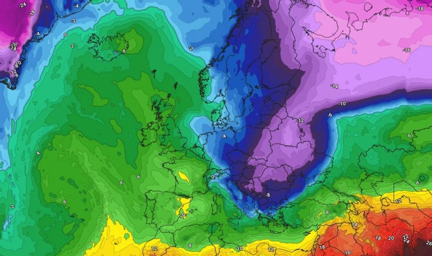
According to data, Eastern Europe, including Turkey, and North Asia will be affected by this polar mass, leading to a significant drop in temperatures and very cold and rainy conditions. Snow may also be present in high elevations, including the Turkish highlands.
Will the cold air mass affect the eastern Mediterranean?
If the weather system continues to stabilize and the cold air mass advances toward Eastern Europe, the effects of its cooler edges may extend to the Eastern Mediterranean. However, it is expected to lose a significant portion of its coldness due to the warming of the Mediterranean waters, which will transform it into a relatively cold air mass. This will cause temperatures to drop in the Levant, Egypt, Iraq, and the northern Arabian Peninsula by the end of next week, where the weather will be cooler, especially at night.
And God knows best.


Arabia Weather App
Download the app to receive weather notifications and more..