عواصف رملية محتملة خلال حالة عدم الاستقرار الجوي

2015-09-13 2015-09-13T09:52:54Z
ناصر حداد
ناصر حداد
متنبئ جوي رئيسي - خبير في الذكاء الاصطناعي

موقع ArabiaWeather.com – يتزامن تأثر المدن الأردنية بحالة من عدم الاستقرار الجوي مع نشاط في الرياح السطحية وتيارات هابطة قد تكون قوية، هذه الرياح من المتوقع أن تعمل على اثارة الأتربة وتشكل الغبار في مناطق متفرقة من المملكة خاصة في جنوب وشرق المملكة وقد تصل الى العاصمة عمان بحيث يحتمل أن يتدنى مدى الرؤية الأفقية في تلك المناطق.


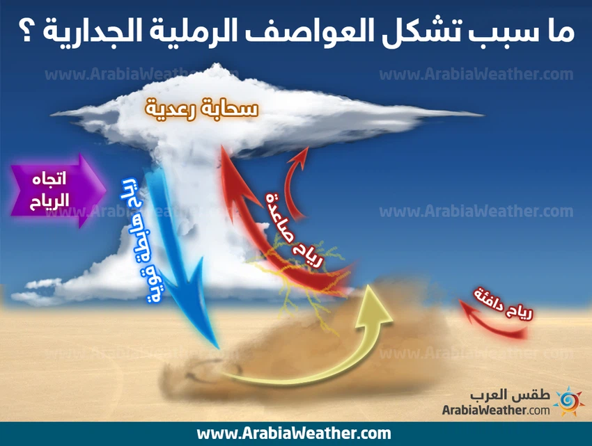
وفي التفاصيل، سيرافق تشكل السحب الرعدية نشاط كبير لكن مؤقت في سرعة الرياح السطحية والرياح الهابطة، هذا من شأنه أن يقلل من مدى الرؤية الافقية بشكل متفاوت من منطقة لأخرى، ويحذر طقس العرب من تشكل العواصف الرملية في الطرق الصحراوية لا سيما الشرقية والجنوبية منها.


يذكر أن المملكة ومختلف دول المنطقة قد شهدت الأسبوع الماضي هبوب لموجة كثيفة من الغبار عبر الأراضي السورية وقد كانت محملة بأطنان من الغبار حيث صاحبها انعدام مدى الرؤية الافقية لفترات طويلة من الوقت.

This article was written originally in Arabic and is translated using a 3rd party automated service. ArabiaWeather is not responsible for any grammatical errors whatsoever.
See More
Related News
Jordan: Which areas are expected to receive rain on Wednesday and Thursday?

Jordan: Which areas are expected to receive rain on Wednesday and Thursday?

Jordan: Watch the brief bulletin in the Arab Weather app. Completely different weather is expected, with rain and a drop in temperature.

Jordan: Watch the brief bulletin in the Arab Weather app. Completely different weather is expected, with rain and a drop in temperature.

Weather maps show the strengthening of polar air and the undulation of the jet stream. What impact will this have on the weather in the Arab region?

Weather maps show the strengthening of polar air and the undulation of the jet stream. What impact will this have on the weather in the Arab region?

Jordan/Winter 2024/2025 Archives: Frequent cold waves and a significant decrease in the number of classified air depressions and rainfall amounts.

Jordan/Winter 2024/2025 Archives: Frequent cold waves and a significant decrease in the number of classified air depressions and rainfall amounts.