كميات الأمطار حتى الثامنة من صباح الثلاثاء وفقًا للأرصاد الجوية

2018-01-02 2018-01-02T12:51:54Z
دائرة الأرصاد الجوية الأردنية
المصدر الحكومي لمعلومات الطقس و الأرصاد الجوية في المملكة الأردنية الهاشمية

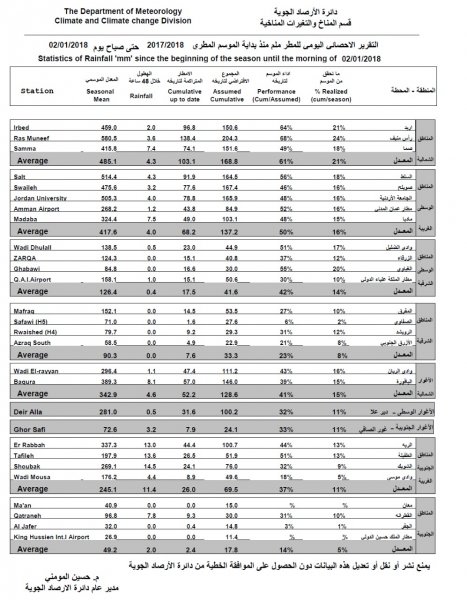
طقس العرب- أكدت دائرة الأرصاد الجوية عبر موقعا الالكتروني أن مجموع كميات الأمطار التي هطلت منذ بداية المنخفض الجوي الذي أثر على المملكة فجر أمس الاثنين حتى الساعة الثامنة من صباح الثلاثاء، وفقًا لبعض محطات الرصد اليدوية والأوتوماتيكية التابعة للدائرة، كانت كالتالي: 


اربد: 2,0 ملم 


راس منيف: 3,6 ملم


صما: 7,4 ملم


السلط: 4,3 ملم


صويلح: 3,2 ملم


الجامعة الأردنية: 4,0 ملم


مادبا: 7,5 ملم


مطار الملكة علياء 1,0ملم


وادي الضليل: 0,5 ملم


المفرق: 0,0 ملم


الرويشد: 0,0 ملم


الزرقاء: 0,0 ملم


الباقورة: 8,1 ملم


الربه: 13,0 ملم


الطفيلة: 13,6 ملم


الشوبك: 14,5 ملم


القطرانة: 7,8 ملم


This article was written originally in Arabic and is translated using a 3rd party automated service. ArabiaWeather is not responsible for any grammatical errors whatsoever.
See More
Related News
The heat dome warns of temperatures exceeding 50 degrees Celsius in five Arab countries in the coming days.

The heat dome warns of temperatures exceeding 50 degrees Celsius in five Arab countries in the coming days.

Relatively hot weather will return to the Kingdom again starting in the middle of the week.

Relatively hot weather will return to the Kingdom again starting in the middle of the week.

Mid-June without heat waves. Do indicators indicate a continued absence of heat waves in the second half?

Mid-June without heat waves. Do indicators indicate a continued absence of heat waves in the second half?

A potential eastern wave could affect several countries in the Arabian Peninsula at the end of June. What is an eastern wave?

A potential eastern wave could affect several countries in the Arabian Peninsula at the end of June. What is an eastern wave?