كميات الهطول المطري حتى الساعة 11:00 صباح الخميس 28-2-2019
2019-02-28
2019-02-28T09:49:50Z

طقس العرب - ما زالت السحب الماطرة تندفع نحو المملكة وبخاصة الأجزاء الشمالية والوسطى ، ويُتوقع خلال الساعات القادمة من نهار اليوم عبور الجبهة الهوائية الرئيسية المُرافقة للمنخفض الجوي تترافق مع رياح غربية نشطة السرعة ، كما يطرأ انخفاض أخر على درجات الحرارة لتُصبح الأجواء شديدة البرودة ، ويُتوقع ان تكون الهطولات المطرية غزيرة مع زخات من البرد والرعد أحيانا وتمتد تدريجياً مع ساعات العصر والمساء نحو الأجزاء الجنوبية من المملكة ان شاء الله.
وتالياً كميات الأمطار حتى الساعة 11 صباح اليوم الخميس 28-2-2019 بحسب محطات طقس العرب المتوفرة:
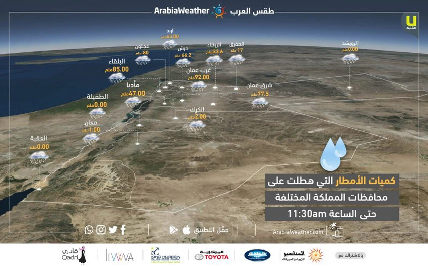
حيث سجلت المحطات القيم التالية:
- إربد: 45ملم
- عجلون: 80 ملم
- جرش: 66.2 ملم
- البلقاء: 85 ملم
- الزرقاء: 33.6 ملم
- المفرق: 17 ملم
- غرب عمان: 92 ملم
- شرق عمان: 77.5 ملم
- الرويشد: 0 ملم
- مأدبا: 47 ملم
- الطفيلة: 0 ملم
- معان: 1 ملم
- الكرك: 2 ملم
- العقبة: 0 ملم
تعرف على احتمالية هطول الأمطار في موقعك
This article was written originally in Arabic and is translated using a 3rd party automated service. ArabiaWeather is not responsible for any grammatical errors whatsoever.


Arabia Weather App
Download the app to receive weather notifications and more..