مركز إعصار هيكا يلامس سواحل سلطنة عمان خلال الساعة القادمة

طقس العرب - سنان خلف - تُظهر آخر صور الأقمار الإصطناعية قرب عين الإعصار هيكا من سواحل سلطنة عُمان، حيث يُتوقع ان تلامس عين الإعصار هيكا المنطقة الواقعة مابين جزيرة مصيرة ورأس مدركة مصحوبة بالرياح القوية.
وتُشير آخر الرصدات الجوية إلى أن الإعصار هيكا يتحرك حالياً بسرعة تبلغ حوالي 24 كم/ساعة، ويترافق برياح تبلغ سرعتها حوالي 120 كم/ساعة وهبات حوالي 135 كم/ساعة.
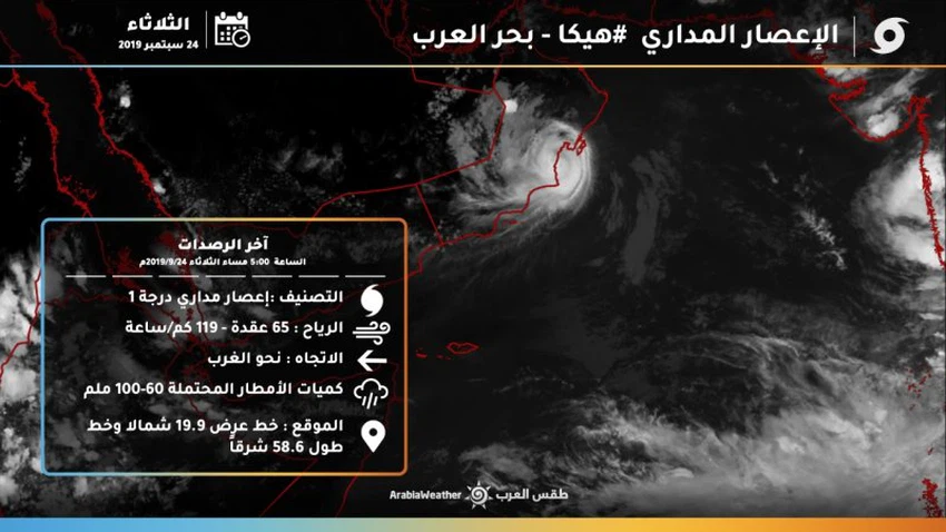
ويبعد تقريباً 20 كم عن السواحل الجنوبية لسلطنة عمان "مدينة الدقم" تحديداً على خط طول 58.6 شرقاً وخط عرض 19.9 شمالاً وسط توقعات بتراجع شدة الإعصار خلال ساعات الليل ليتحول إلى عاصفة مدارية.
ومن المتوقع أن تبلغ كميات الأمطار ما بين 60 إلى 100 ملم، مما يعمل على ارتفاع بمنسوب المياه بشكل كبير و تشكل السيول وجريان الأودية
تحذيرات هامة:
1- خطر تطاير الاجسام بسبب شدة الرياح التي تبلغ 135 كم/ساعة
2- خطر إرتفاع منسوب المياه نتيجة غزارة الأمطار.
3- خطرة جريان الأودية والسيول
4- شدة اضطراب البحر وارتفاع الأمواج


Arabia Weather App
Download the app to receive weather notifications and more..