From Algeria to Saudi Arabia.. an air depression that affects 10 Arab countries in the coming days

Weather of Arabia - The outputs of analyzes and computer simulation data of weather forecasts indicate predictions of a rush to the center of the Mediterranean Sea, the regions of Italy, a cold and humid air mass in the high layers of the atmosphere, and it takes an unusual path inland from the Libyan and then Egyptian lands and continues its path towards Saudi Arabia, in conjunction with the extension of The Red Sea depression is on the surface towards the region and the north of the Arabian Peninsula, and this convergence will lead to the emergence of unstable weather conditions in many Arab countries.
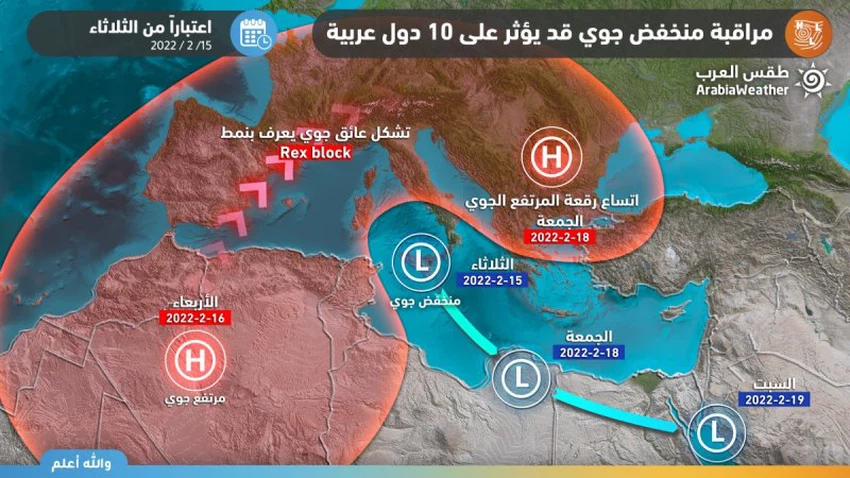
One depression crosses 10 Arab countries, and the effects vary from one country to another
It is expected that the weather disturbances will start on Tuesday in parts of northern Algeria and Tunisia, to transfer the event on Thursday to Libya, and soon extend to Egypt on Friday, with the effect of the weather disturbances expanding early next week to include many Arab countries, namely: Jordan, Palestine and Lebanon And Syria, Iraq, and parts of northern, western and central Saudi Arabia, God willing, and may extend later to Iraq and Kuwait in the sea next week, provided that the effects of the depression differ from one country to another.
These weather disturbances come on a regional scale, as a result of a low air rush in the high layers of the atmosphere towards the middle of the Mediterranean Sea, which quickly moves to the Egyptian lands, in conjunction with the blowing of warm and humid air currents from subtropical shows, which leads to the emergence of unstable weather conditions and a surface response. The Red Sea depression is clearly and effectively, before it turns into a frontal depression at the beginning of the week, when the weather is at its peak inside the Kingdom of Saudi Arabia, to increase the intensity of thunder clouds and the intensity of rain.
Read also:
Scientifically, it forms a closed air obstacle known as (Rex Block)
The reason for expectations of the crystallization of these weather conditions is due to the formation of a closed air system (Blocking Pattern) on the European continent, this system is known as (Rex Block), meaning that the cold masses in the high layers of the atmosphere become confined and slow in movement and surrounded by high altitudes in the north.
The crystallized depression takes on the characteristics of what is known as a cut off low, which is an atmospheric depression that extends from the upper layers of the atmosphere to the surface of the earth; It is formed as a result of a final separation from the path of the basic state, and the air altitude plays a major role in the process of separating it, and the effect of such systems usually lasts for several days, and the same regions are affected by the consequences of the depression without the other.
Very difficult to simulate the path of the depression
Perhaps the progress and passage of time during the next two days will be sufficient to accurately explain the effects of the depression on the Levant, Egypt and Saudi Arabia. , in addition to the inability to sense the values of the vertical thermal difference associated with the depression and the angle/deepening of the depression, so please follow the weather bulletins issued on a daily basis that will shed light on more details in an ascending manner, God willing.


Arabia Weather App
Download the app to receive weather notifications and more..