New low depression affects Saturday and cold front crossing in the evening

Weather of the Arabs - an aerial elevation is still concentrated over many European regions, bringing warmth and stability to these regions, and as a result, a new cold air mass rushes around this air elevator towards Turkish lands directly and then towards the eastern basin of the Mediterranean and the Levant.
A new low depression is born on Saturday and a cold air front crossing in the evening and night
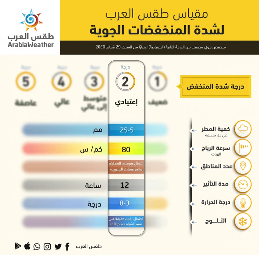
As a result of the availability of many other appropriate conditions, it is expected that a second-degree air depression will be established according to the Arab weather classification for the severity of the air depressions, God willing, will be centered to the northeast of the island of Cyprus, on Saturday evening, as the region crosses a cold air front of this air system, and will be Its influence is clear and strong over western Syria and Lebanon, and less so over the kingdom.
This front will work on the regularity of rain in the north and central of the Kingdom, God willing, with the hours of the first Saturday / Sunday night, and then towards the southern mountainous highlands, and, God willing, these rains will be heavy for brief periods and accompanied by thunderstorms and hail.
Unstable weather on Saturday morning, due to the convergence of the cold air mass with warmer air over the area
We return to talking about the hours of Saturday morning, where temperatures decrease significantly compared to the pleasant Friday weather, and cumulative clouds multiply over many regions, especially the northern and central areas, where the opportunity is created for local thunder showers of rain, God willing, but for short periods, and gradually activate Wind with daylight hours and cold and partly cloudy weather continues.
Weather activity eased on Sunday, with still active winds blowing
This depression is moving rapidly towards the east towards the north of Iraq, where the air activity decreases rapidly with the hours of dawn and Sunday morning, but with cold climates and continuous active northwesterly winds, the air activity ends completely in the evening and fog forms at night over many areas.


Arabia Weather App
Download the app to receive weather notifications and more..