Advanced alert | Arab Weather issues details of the tropical situation, Shaheen, and a list of areas covered by rain forecasts and their intensity

Update || Thursday 2/10/2021 at 2:30 pm:
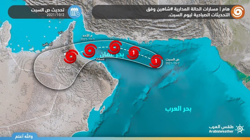
Arab Weather - The latest satellite images received at the Arab Regional Weather Center, in addition to remote sensing observatories, show the continued movement of Tropical Cyclone Shaheen to the west towards the west of the Sea of Oman, centered at the time of preparing the report, east of the Sea of Oman at latitude 24.2 north and longitude 61.8 east, The speed of the surface winds around the center is estimated at 60 to 70 knots, and the center of the cyclone is about 330 km away from the coast of Al-Satanah.
Tropical state weighted path based on recent updates
The classification of the cyclone fell to a storm in conjunction with its approach to the coast of the Sultanate
In the details, it is likely that the tropical situation will move in the coming hours towards the western direction along the coasts of the Sultanate overlooking the Sea of Oman, accompanied by indirect effects on those areas, so that rain showers are expected to fall on parts of the coastal areas, including parts of South Al Sharqiah. In North Al Sharqiah and Muscat, the surface winds are actively accompanied by high waves in the northeastern coastal areas.
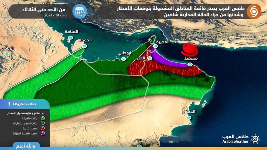
And with the late morning hours of Sunday, and with the tropical situation approaching the Sultanate, specifically towards the coasts of North Al Batinah, the actual and direct effects of the tropical condition Shaheen are expected to begin, which will lead to heavy to very heavy rain in the governorates of North and South Al Batinah, Al Buraimi and parts of Muscat, Al Dakhiliyah and Al Dhahirah , while the effects are less severe on the governorates of Musandam, North and South Sharqiyah, and no direct effects of the tropical situation are expected on the governorates of Al Wusta and Dhofar.
A large amount of rain is expected
The areas most affected by the tropical state of Shaheen
The expected amounts of rain in many regions of the Sultanate, especially the north and south of Al Batinah, parts of Al Buraimi, the north of Al Dhahirah Governorate, the north of Al Dakhiliyah Governorate and west of Muscat range between (200-400 mm), and these amounts of rain are sufficient to form large floods and torrential torrents. It is still solid after its impact on the Sultanate of Oman, between its direct impact on the Emirates, reaching the interior and coastal regions of it, and between limiting its influence to the southern and eastern parts of it.
However, it is expected that there will be direct and strong effects of the tropical situation on the eastern and southeastern parts of the UAE, starting from the evening hours of Sunday, so that heavy rain will fall in most of it, causing floods, wadis flow and high water levels on the roads, extending to some of the interior areas.
It is worth noting that the tropical conditions contain very huge amounts of relative humidity, as this humidity rushes after the weakening and decay of the tropical condition into the Arabian Peninsula, working to provide a near-perfect environment for the proliferation of thunderclouds to include parts of the interior and coastal regions of the Emirates in addition to parts of the quarter Empty.
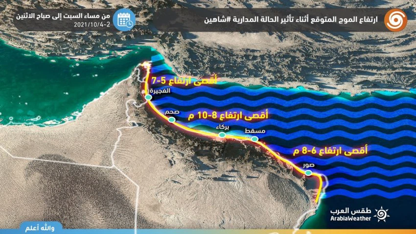
The wave height is about 10 meters in some coastal areas
Direct effects of the Shaheen Tropical Condition on Maritime Navigation
It is expected that the tropical situation will be accompanied by strong winds ranging between 55-65 knots (100-120 km/h) and high waves with an estimated height of about 8-10 meters, which means severe sea turbulence, sea water entering coastal areas and flooding with water, and disruptions All marine navigation works, including the closure of ports.
The Arab Weather Center calls on the residents of those areas to take the utmost care and caution during the coming days in order to preserve lives due to winds, strong waves and heavy rains capable of forming torrential floods, God forbid.


Arabia Weather App
Download the app to receive weather notifications and more..