Arab World Weekly | Gradual domination of the Awzurian Highland over the western Mediterranean and the extension of the Red Sea depression over the Arabian Gulf and the Levant

Arab Weather - according to the latest numerical weather forecasts, a large discrepancy is expected on weather systems during the current week between stable weather and a significant rise in temperatures, and between low temperatures and precipitation, details
Gradual domination of the Awzurian Highlands over Morocco and Algeria, and the possible weekend of Jop
The Aouzrian air altitude dominates the Maghreb at the beginning and the middle of the week, when the weather stabilizes and temperatures rise, while Algeria is affected by a cold air mass rushing from the European continent, where temperatures drop, and showers of rain fall on the northern parts of Algeria in the throwing of Sunday and Monday, while The Ouzourian highland controls Algeria from Tuesday.
While the outputs of numerical models indicate that there are indications that Morocco and Algeria will be affected by a cold air mass and an air depression during the weekend, as temperatures recede and rain falls on Morocco and later Algeria, God willing.
A cold air mass over Tunisia and Libya at the beginning of the week, and the control of the Aouzourian high after the middle of it
Tunisia and Libya are affected by a cold air mass rushing from the European continent during the weekend, as temperatures drop, showers of rain fall on Tunisia and the northern parts of Libya, and the impact of the Osouri highland on Tunisia deepens, so that the atmosphere stabilizes by the middle of the week.
While the effect of the cold air mass on Libya is deepening and showers of rain fall in the north and center of the country, and this coincides with activity on the speed of the winds, which leads to disturbance of sea waves on the beaches, while the atmosphere returns to stability as a result of the control of the Osorian high in Libya, starting from Wednesday and at the end of the week.
High temperatures in Egypt and Sudan and a cold air mass, starting from Wednesday
As of Sunday, Egypt is affected by the extension of the Red Sea Depression, where temperatures rise significantly during the day, while the weather remains relatively cold at night, and a cold air mass accompanying an air depression in the upper atmosphere rushes in conjunction with a surface extension of the Red Sea depression, and a state of absence Air stability, starting from Wednesday, and its impact increases dramatically by the end of the week.
While Sudan is exposed to the extension of Sudan's seasonal depression, which leads to a remarkable increase in temperatures, especially in the southern regions, especially with the middle of the week, and some rain may fall on the coasts at the weekend, while a less hot air mass approaches the north of the country within a day. Thursday, and the weather becomes moderate in the north and center of the country, but it remains hot in the south.
An air depression on Syria and Iraq on Sunday, and the stability of the skies in the rest of the Levant countries
Syria is affected by an air depression on Sunday, as rain falls in different parts of the country, and the impact of the depression extends towards Iraq, as rain falls in parts of the State of Iraq, while the Levant and Iraq are affected by the extension of the Red Sea depression, which causes a significant increase in the Temperatures.
There are also initial indications of a cold air mass moving in the upper air layers from Egypt to the Levant and Iraq, and coincides with the extension of the Red Sea depression, which causes the emergence of a state of air instability in all countries of the Levant in addition to Iraq, and its details will be reviewed later, God willing. .
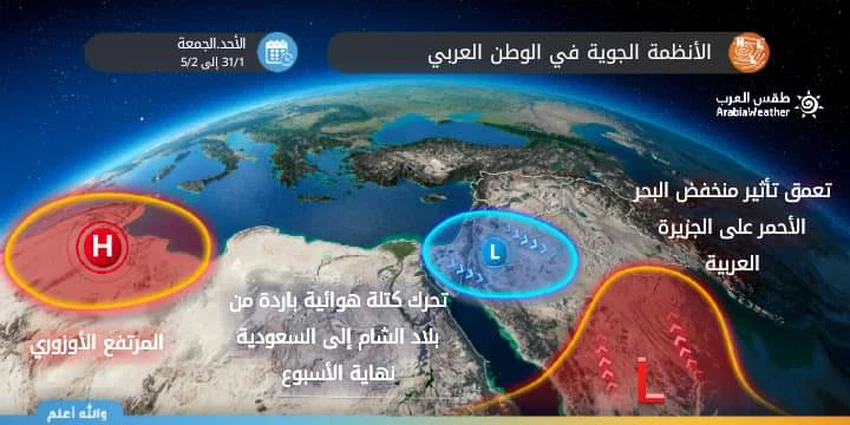
The extension of the Red Sea depression on the Arabian Peninsula, and a cold air mass in northern and central Saudi Arabia at the weekend
All the countries of the Arabian Peninsula are affected by the extension of the so-called Red Sea Thermal Depression, where an escalating rise in temperatures occurs, especially with the middle of the week, and the atmosphere remains stable, and temperatures are thirty days during the day, especially in the UAE, southern Saudi Arabia, Oman and Yemen.
Whereas, Saudi Arabia is affected by the end of the week by the eruption of a cold air mass coming from the Levant, where temperatures recede, and Saudi Arabia is affected by a state of atmospheric instability, with thunderstorms raining in many parts, in the same context the atmosphere remains stable and temperatures are thirty in the rest Arab Gulf states, and the impact of unstable weather is limited to Saudi Arabia during the weekend.
God knows.


Arabia Weather App
Download the app to receive weather notifications and more..