Egypt Weather Update # Wednesday of the depression and weather conditions in Egypt.

Weather of Arabia ... Antonios Mekhiel ...Wed 11-03-2020:
With evening hours of the day:
A cold air mass rushes in the upper atmosphere towards the west of the country, converging with a humid tropical air mass associated with the low seasonal Sudan, which works to multiply the thunderstorm clouds on parts of the northern and northern Upper Egypt coasts, and extends to Cairo, the Delta, the Canal cities, South Sinai and parts of the northern Red Sea so that they are accompanied Showers, thunderstorms sometimes, with chances of hail.
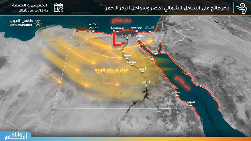
The situation is actively associated with the northeastern winds on the north and west of the country, so that they are dust and dusty in some of these areas, especially those that have desert backs, while they are eastern to southeasterly, and are velocity dusting in southern and central Upper Egypt.
Thursday: peak weather with chances of torrents forming and high water levels
A deep, highly effective atmospheric depression with tropical properties is formed in a situation considered historical in terms of rainfall amounts, duration of impact and accompanying weather phenomena, concentrated on the north of the country, which works heavy rainfall with chances of hail falling on large areas of the northern coasts, delta, Cairo, north and central Upper Egypt, canal cities, Sinai and North The Red Sea, which works to form torrents for coastal governorates such as Matruh, Sinai, the Red Sea, and high water levels in the Delta, Cairo, Canal cities, and northern Upper Egypt.
Temperatures drop in most areas to make temperatures below their rates, and active winds and rain increase the feeling of lower temperatures.
Strong winds that accompany the depression, which excites dust and dust in some areas, up to the dust storm in some areas.
High waves in white and red Bahrain, which will strike traffic and marine activities.
Friday: Thunderstorm opportunities persist in many regions, but with less intensity
The strong efficiencies of the depression continue, but with less intensity, as the chances of heavy thunderstorms continue at times on the northern coasts, the Delta, Cairo, Canal cities, northern Upper Egypt, the Sinai and the northern Red Sea, and snowfall opportunities increase in St. Catherine heights.
The winds are northwesterly to strongwesterly, causing dust and dust over parts of the north of the country, while strongwesterlywesterlywinds are exciting for thick dust that reaches the storm’s level at the Red Sea and Sinai.
The waves rise further in the Mediterranean, which increases the turbulence of the sea and the difficulty of marine activities, while the waves are medium to high in the Red Sea, which creates a partial disruption in the movement of navigation.
Saturday: the depression moves toward the Levant and the parts gradually stabilize
The depression is moving towards the Levant and the atmosphere is gradually stabilizing, but the opportunity remains for separate showers of rain on parts of the northeast of the country, which include Sinai and Canal cities
The winds are active in the west, causing light dust in some areas
The waves are moderate, which helps in the regularity of navigation and most marine activities.
Warnings:
1 - It is expected that torrents will form especially in Mersa Matruh, Sinai and the Red Sea mountains, so please stay away from the torrents.
2 - It is expected that the water level will rise in some areas such as Alexandria and parts of the north and central delta and Cairo. It is advised to stay away from low areas such as tunnels.
3- Strong winds expected on the north of the country and up to the north and central Upper Egypt and the northern Red Sea, causing dust in some of these areas.
4- Strong turbulence in the Mediterranean Sea, especially with the end of the week, which may lead to the closure of ports and the stopping of maritime traffic. It is kindly requested that fishermen and seafarers take caution.
5 - It is expected that snow will fall on the mountains of St. Catherine. Please, gentlemen, the tour operators, to avoid this period as a result of violent air turbulence.


Arabia Weather App
Download the app to receive weather notifications and more..