For the third year in a row, the end of August brings with it the beginning of the impact of a heat wave on Jordan

Arab weather - in contrast to the popular proverb that (the end of August of summer is lame), the Kingdom is affected from Saturday 8/27-2022 by a relatively long heat wave that continues with varying intensity from day to day until the first week of September, and the weather is hot It is generally dry in most areas, and very hot in the Jordan Valley, Dead Sea, Gulf of Aqaba and Badia regions.
Similarly, the climate archive data showed that the Kingdom was affected during the period from August 26-29, 2021 by a heat wave, but it is of less life and intensity if compared to that expected to affect the Kingdom in the coming days. According to the same data, the Kingdom was also affected, with the 29th of August 2020, by the longest heat wave since the start of recording climatic records in the Kingdom, that is, about 100 years ago, as it continued its effects until the eleventh of September and was accompanied by unprecedented values.
As for the scientific reason behind the high chances of heat waves occurring in the region during this period of the year, the specialists at the Arab Weather Center believe that this period of the year witnesses a rapid change in atmospheric systems, as the atmosphere begins to play an active dynamic of the seasonal shift, conflict and overlap between The effect of hot masses centered over the Arabian Peninsula and between the extension of the less hot (moderate) masses across the Mediterranean.
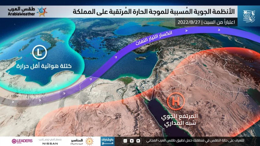
Regarding the atmospheric system that causes the eruption of the hot mass expected on the Kingdom, the specialists at the Arab Weather Center said that a rise in atmospheric pressure in the Arctic Dome is causing a refraction in the jet streams to become more active and push cold air more than normal towards semi-arid regions. Tropical (similar to opening a refrigerator door), and as a result of the distribution of air systems in the northern half of the Atlantic Ocean, the air rise in the British Isles will direct the path of cold air and push the moderate air masses south towards the middle of the Mediterranean Sea, and this results in an intensification of the height The semi-tropical atmosphere and the hot air mass accompanying it this time over the Levant and the north of the Arabian Peninsula and supported by a temperature depression on the surface, as these weather elements will keep the hot weather over the Kingdom for many days.


Arabia Weather App
Download the app to receive weather notifications and more..