How did the snow disappear from the Kingdom's highlands despite the abundance of rain?

Arab Weather App - The Levant region, including Jordan, has witnessed a succession of low-pressure systems over the past few weeks, thanks be to God, which has contributed to abundant rainfall compared to what is expected so far. Meanwhile, snow has been absent from most of the Kingdom's highlands, except for the southern peaks (the Sharah Mountains), despite the region being affected by several cold and humid air masses. What is the reason for this?
How did the snow disappear despite the abundance of rain?
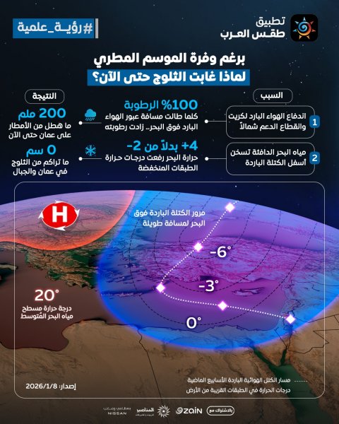
The primary reason for this is the way cold air masses from the north move over the Mediterranean Sea, and the thermal and moisture content they acquire as they pass through. Over the past few weeks, a cold air mass has been moving along the western axis of Turkey and the area around Crete, coinciding with a break in the flow of cold air from the north as it moves eastward towards the Levant and Jordan. When these air masses travel long distances over the sea, especially when it is relatively warm, as it is now at around 18-20 degrees Celsius, the lower layers of the air begin to absorb significant heat and moisture from the sea surface. This causes the temperature of the layer near the surface to rise to values typically between 2 and 6 degrees Celsius, temperatures insufficient to sustain precipitation as snow.
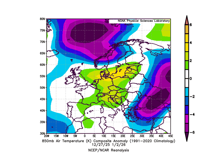
During this prolonged passage of the cold air mass over the water, humidity in the lower layers rises to saturating levels, reaching up to 100%. This allows for the formation of dense stratus clouds, accompanied by heavy and continuous rainfall during the weather system's influence. However, this high humidity does not contribute to cooling the surface air; on the contrary, it increases rainfall at the expense of snowfall. This is because the snow that forms in the upper layers melts immediately upon entering the warmer layers near the Earth's surface. This means that the cold present in the middle and upper layers alone was insufficient to counteract the continuous heating coming from the sea.
Furthermore, the cold air masses originating from northern Europe were neither strong nor sustained enough to offset the lower-level heating from the sea, causing the cold air masses to lose their lower-level characteristics over time. As a result of these combined factors, rainfall increased due to high humidity and strong atmospheric instability, while snowfall disappeared due to the warming of the lower layers.
What is the path that causes snowfall in Jordan?
Although snow fell and accumulated over the southern peaks (the Sharah Mountains) on December 17, snowfall over the high and medium mountain ranges, including the Oman highlands, requires more complex weather systems to produce snowfall, including the descent of the polar air mass into the water basin from the eastern Mediterranean Sea vertically in the vicinity of Cyprus, so that a low-pressure system is formed and acts as a generator for widespread rain/snowfall.
Thus, it can be said that the abundance of rain and the absence of snow so far are not contradictory, but rather a direct result of the effect of warm Mediterranean waters on cold air masses. This warming and high humidity transform potential snowfall into heavy rain before it reaches the ground. We ask God to bless us with beneficial rain and abundant snow.


Arabia Weather App
Download the app to receive weather notifications and more..