important | A few hours before the center of Cyclone Shaheen landed on the coasts of the Sultanate

Update || Sunday 10/03/2021 at 16:00:
Arab Weather - The latest satellite images and remote sensing centers show the continued movement of Tropical Cyclone Shaheen slowly along the coasts of the Sultanate overlooking the Sea of Oman, accompanied by severe turbulence in the Sea of Oman and continued rainfall in coastal areas and parts of the interior, especially those located in the governorates of Muscat and South Al Batinah.
Close-up: Follow satellite images of Storm Shaheen and its approach to the coast of the Sultanate
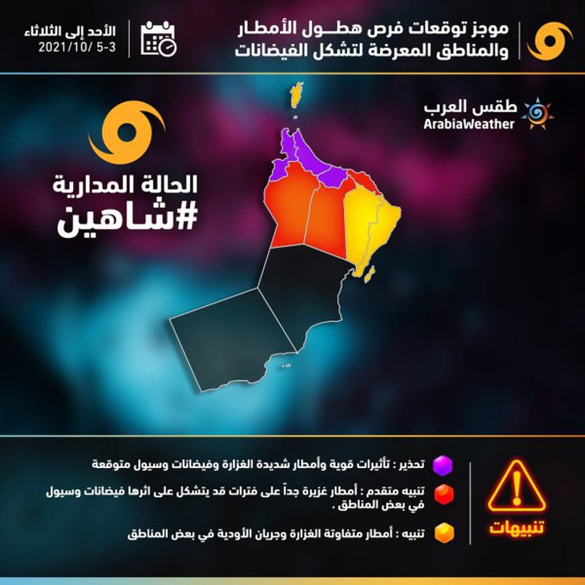
Possible floods in the north and south of Al Batinah, Al Buraimi and other governorates
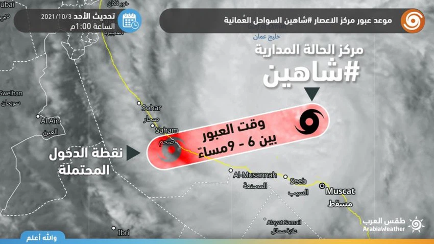
Several hours separate cyclone Shaheen from hitting the coast of the Sultanate
In the details, the hurricane Shaheen is stationed at the hour of preparing the report to the northwest of the Governorate of Muscat, away from approximately 60 km from the capital, and the wind speed is estimated around the center of the hurricane is 70 knots (130 km / h), and towards the next few hours it is expected to approach the center of the tropical situation Shaheen. From the coasts of North and South Al Batinah, the rains will become heavy to very heavy, and the amounts of rain expected in those areas range between (200-400 mm) in addition to the governorates of Muscat, Al Buraimi, Al Dhahirah and Al Dakhiliyah.
These large amounts of rain are enough to form large floods and torrential torrents, and the tropical situation is accompanied by strong winds ranging between 55-65 knots and high waves estimated at a height of about 8-10 meters, which means severe sea turmoil, and the entry of sea water on coastal areas. And flooded it with water, and disrupted all marine navigation, including the closure of ports.
Under these circumstances, the Arab Weather Center calls for the necessity of taking the utmost care and caution and not to risk crossing valleys and to stay away from low places. It also warns against going to the sea during the coming days.
The weather forecast staff in the Arab weather believes that the most areas will be subject to heavy rain and high winds in addition to floods are (North Al Batinah, South Al Batinah and Al Buraimi) and with a relatively less intensity parts of (Muscat, Al Dhahirah and Al Dakhiliyah), while the impact is different and less dangerous in (North Al Sharqiah and South Al Sharqiah). And Musandam), but the governorates of South Al Sharqiyah and Musandam, although rain opportunities are not focused on them, will be directly vulnerable to sea turbulence and the entry of sea water into the coastal areas of them, and it is not expected that the direct effects of Hurricane Shaheen will affect the governorates of Al Wusta and Dhofar.
The Omani governorates are divided according to the severity and severity of their impact on Cyclone Shaheen, as follows:


Arabia Weather App
Download the app to receive weather notifications and more..