important | The most dangerous areas in the Sultanate of Oman, which will be under the direct influence of Hurricane Shaheen during the next 48 hours

Arab Weather - The weather forecast staff at the Arab Regional Weather Center continues its continuous and diligent follow-up on the developments and developments of Tropical Cyclone Shaheen, which has become a real threat with its potential direct effects on the Sultanate of Oman and the United Arab Emirates, bringing with it strong winds, high waves and heavy rain.
Omani areas in danger
High winds, sea waves and heavy rain
The latest output of our computer simulation systems for rain forecasts in the Arab weather calculates that Cyclone Shaheen carries with it huge amounts of rain, ranging between 200-500 mm, that are expected to fall on the regions of the Sultanate, which is a large amount capable of causing floods and forming strong and torrential torrents in many areas. The Omani governorates can be divided according to the severity of their impact on Cyclone Shaheen as follows:
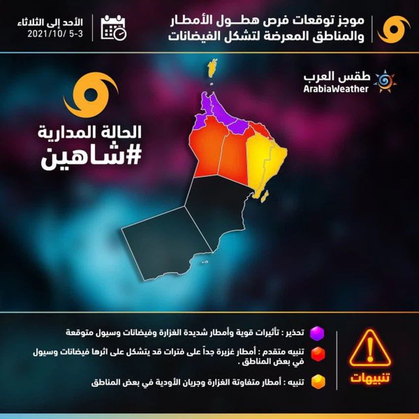
First: Governorates in the danger circle:
North Al Batinah - South Al Batinah - Al Buraimi: direct effects, heavy rains, torrential rains and expected floods
Secondly, the provinces are less dangerous
Muscat - Al Dakhiliyah - Al Dhahirah: Very heavy rains at intervals that may form torrents and floods
Third: Areas that will experience regular heavy rains
North Al Sharqiyah - South Al Sharqiah: Rain of varying intensity, flow of valleys and torrential rains in some areas
Follow the satellite images and the movement of the moving clouds now for the Arabian Sea and the Sea of Oman, from here
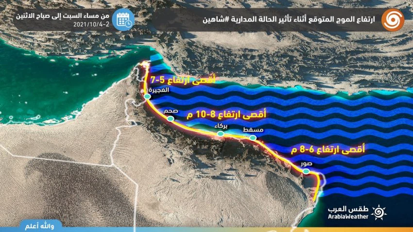
The wave height is about 10 meters in some coastal areas
Direct effects of the Shaheen Tropical Condition on Maritime Navigation
It is expected that the tropical situation will be accompanied by strong winds ranging between 55-65 knots (100-120 km/h) and high waves with an estimated height of about 8-10 meters, which means severe sea turbulence, sea water entering coastal areas and flooding with water, and disruptions All marine navigation works, including the closure of ports.
The Arab Weather Center calls on the residents of those areas to take the utmost care and caution during the coming days in order to preserve lives due to winds, strong waves and heavy rains capable of forming torrential floods, God forbid.
Read also:


Arabia Weather App
Download the app to receive weather notifications and more..