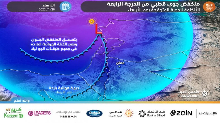
In the illustrative maps, a fourth-degree polar depression begins on Wednesday, with snow affecting different regions of the Kingdom
Arab weather - m. Nasser _ Haddad The Levant region, including Jordan, is affected by an air depression of polar origin classified as a fourth degree (highly effective), gradually during the day Wednesday, corresponding to January 26, 2022 and continues with varying severity also during Thursday, bringing with it rain and bounties for various regions and snow over the areas that Its height is more than 800 meters above sea level, God willing.
Intermittent precipitation of rain and snow precedes the crossing of the cold air front
It is expected that the amounts of convective clouds will increase in some areas, especially during the noon hours, so that the chances of sporadic and intermittent showers of rain rise, in the form of showers of cold or snow over the mountainous heights.
The wind movement gradually becomes active with some strong gusts and causes dust, especially in desert and open areas, provided that the winds intensify before crossing the cold air front, God willing.
A polar air front crosses the Kingdom with the afternoon and evening hours.. with snow falling over 800 meters
Between afternoon and evening, the Kingdom crosses a polar air front accompanying the depression centered on the coasts of Syria, so that there is another significant decrease in temperatures and snow gradually begins to fall (starting in the afternoon hours) over the mountainous heights that are more than 800 meters above sea level and include areas Several of the capital and other major cities and is associated with the occurrence of thunder sometimes. Precipitation will be less than that height in most areas, accompanied by showers of hail.
Recommendations for Wednesday
- Attention to the danger of snow accumulation in different regions of the Kingdom
- Be aware of the danger of high wind speed
- Be aware of the danger of reduced horizontal visibility due to dust waves.
Weather condition during the period of impact of the peak depression .. Know when and how long it will last?
The intensity of the weather activity is expected to gradually increase with the evening hours, as the air front is completed in the middle and upper layers of the atmosphere, and the density of clouds increases and becomes high, and the peak period continues during the night hours until the dawn and early morning hours of Thursday, and the weather conditions will be during the peak impact period. as follows:
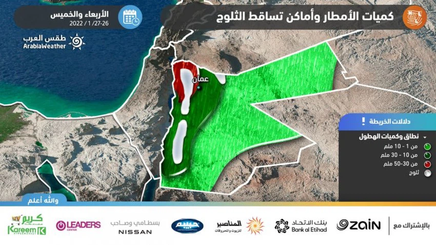
The weather will be very cold, stormy and cloudy, with snow falling and accumulating on most of the heights that are more than 800 meters above sea level in the north and center of the Kingdom and are accompanied by the occurrence of thunder. The snow is sometimes heavy and extends to areas of lower elevation for some times. The precipitation is rainy in low areas and is sometimes associated with showers of hail. The winds are southwesterly to westerly strong, with strong gusts at times.
While the Gulf of Aqaba is expected to become medium to high waves with the afternoon and evening hours, as some waves may reach a meter, with a warning against going to the sea and using small and glass boats.
Recommendations for Wednesday/Thursday night
- Attention to the danger of snow accumulation in different regions of the Kingdom
- Be aware of the danger of strong wind speed.
- Danger of reduced horizontal visibility due to heavy precipitation
Thursday.. the depression is moving away from the region, while the kingdom is gradually affected by polar and humid air currents
Temperatures are cooler than normal by more than 10 degrees Celsius. The weather will be very cold and cloudy, with snow falling from time to time on the mountainous heights that are more than 800 meters above sea level, while it will rain in the lower areas. Low clouds touching the surface of the earth cross the mountainous regions, causing fog to form. In the afternoon hours and thereafter, the level of snowfall rises to 1,000 meters above sea level, so that areas that are lower than that receive rain or snow precipitation. The wind is westerly brisk, with strong gusts at intervals.
Thursday's recommendations
- Attention to the danger of snow accumulation in different regions of the Kingdom
- Danger of reduced horizontal visibility due to fog and clouds touching the surface of the earth
- High wind speed danger
For more news, download the Arabia Weather app from here
God knows.


Arabia Weather App
Download the app to receive weather notifications and more..