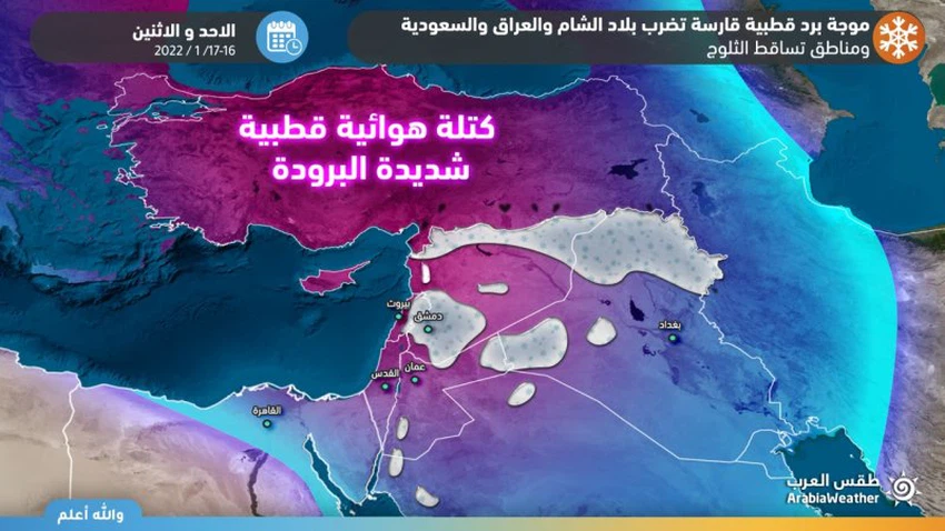
Iraq Weekly Bulletin | A frigid Siberian polar air mass brings rain, snow showers and indications of a new polar eruption after midweek.

Arab Weather - The latest output of the numerical weather models processed by the Air Operations Department at the Arab Regional Weather Center indicates the occurrence of important weather fluctuations in Iraq early next week, represented by the crossing of a cold air front that rushes a very cold Siberian polar air mass, starting from Sunday and for several days, amid expectations of precipitation. Snow in areas that rarely witness snow, followed by a wide wave of ice. Details
A cold air front crosses the morning and Sunday morning, with very cold Siberian winds rushing behind it
The Arab Weather Center expected that Iraq will cross as of Sunday morning and during the day, a cold air front with very cold Siberian polar winds rushing behind it, so there is a significant drop in temperatures, especially in the western and northern regions, and the weather becomes very cold in the northern heights, and very cold in The north and west of the country, while it is relatively cold to cold in the rest of the regions.
The cold air front begins to cross from the northern and western regions during the morning and Sunday morning, pushing large amounts of rain clouds that coincide with the beginning of the flow of polar winds, and showers of rain fall on the north and west of the country. Low and in contact with the earth's surface, it forms dense fog.
Snow over the mountainous heights that rise 800 meters in the north, and rare snow showers in western Iraq
With the crossing of the cold air front and the flow of polar winds in the layers of the atmosphere in a way that allows snowfall to occur, it is expected, God willing, that the dense and accumulated snow will fall over the northern mountainous heights, which are more than 800 meters above sea level, on Sunday.
It is also expected, by will, as a rare weather event, that areas in western Iraq will witness snowfall during the crossing of the cold air front. The snow is dense and accumulated, and includes, including the western humid areas such as Mahfoor Al-Jundi, and also includes desert roads such as the Baghdad International Road in addition to the Trebil border crossing. Snow expected on the west is rare because these areas are not accustomed to receiving snowfalls.
The crossing of the cold air front on Sunday/Monday night moves to the central regions
With the night hours of Sunday / Monday, the crossing of the cold air front moves to the central regions, and heavy rains and heavy hail continue to fall on the northern regions, with heavy and accumulated snow falling over the northern mountainous heights, while rainy clouds also move to the central regions, including the capital, Baghdad, as the front crosses Cold air, where showers of rain and hail fall over central Iraq, and the chance of snow showers over the western regions remains, coinciding with the crossing of low clouds touching the surface of the earth leading to the formation of thick fog.
Arctic Siberian winds, freezing cold on Sunday/Monday night, and a wide wave of ice deepen
With the cold air front crossing the central regions, the weather forecast staff at the Arab Regional Weather Center is expected to deepen the influence of the very cold Siberian polar air mass and be stationed over Iraq on Sunday/Monday night, leading to the flow of cold northwestern winds as temperatures drop sharply and tangibly to become Temperatures are below zero degrees Celsius in large areas of western and northern Iraq, and the roads are still wet, which leads to the formation of a large-scale ice wave over those areas. The ice formation includes internal and external roads in cities, which poses a real danger when walking on the roads, while the rest of the areas witness severe weather. Cold and temperatures are very low, reaching only 3 degrees Celsius in the capital, Baghdad, while they are slightly higher in the southern regions.
The control of the very cold Siberian polar air mass over Iraq, Monday
It is expected, according to the latest outputs of numerical weather models, that the impact of the very cold Siberian polar air mass will deepen on Iraq on Monday, as there is a sharp drop in temperatures to be below rates for this time of the year, where temperatures range between 4 and 10 degrees in most regions of Iraq. It will be below zero degrees by several degrees in the northern mountains, and the weather will be very cold in the northern highlands, and very cold in the rest of the regions, with ice forming on the roads that witnessed snowfall, especially in the morning hours.
Clouds continue to appear at different altitudes, especially in southern and eastern Iraq. Showers of rain and hail fall on the eastern and southern regions, and snow falls on the northern and northeastern mountainous heights as a result of the remnants of the cold air front that crossed later.
Winds will be northwesterly moderate to brisk, accompanied by strong gusts exceeding the 50 km/h barrier and significantly increasing the sense of cold.
More cold Arctic Siberian winds flow towards Iraq on Monday/Tuesday night and temperatures around zero degrees Celsius in Baghdad
The Siberian polar air mass is moving towards the south and pushing freezing cold winds towards all regions of Iraq, reaching their peak on Monday/Tuesday night, as temperatures drop in all regions of the country to be below zero by about 14 degrees Celsius in the northern peaks, while they are between 3- to 6- degrees Celsius in the northern and western regions, while temperatures are between 2 and 2-in the rest of the central and southern regions, and temperatures approach zero Celsius in the capital, Baghdad, for the first time in several months.
With freezing forming in large areas of the country, and ice forming on wet roads amidst unusual for Iraq and Siberian polar temperatures par excellence.
Watching a new frigid air mass surge after the middle of the week
The weather forecast staff at the Arab Weather Center monitors the possibility of a frigid Siberian polar air mass rushing towards the country after the middle of the week, bringing with it very cold weather and renewed rainfall and possibly snow, especially over the northern peaks, and Arab Weather will provide you with all the details later.
In light of the expected weather conditions, the Arab Weather Center advises the necessity of:
- Attention to the danger of torrential rains and the flow of valleys in some areas
- Attention to the danger of falling and accumulating heavy snows and the occurrence of road closures and impeding the aspects of public life in the exposed areas
- Attention to the danger of freezing and icing, which poses a danger to driving on the roads and to livestock plants, so it is advised to prepare early for this
- Reducing and not driving on roads that witness the formation of ice, especially on Monday morning
- The safe use of heating devices and heavy clothing, especially for the elderly and children.
For more news, download the Arabia Weather app from here
God knows.


Arabia Weather App
Download the app to receive weather notifications and more..