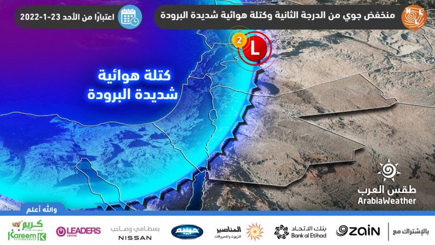
Jordan | A second-degree (normal) depression, starting from Sunday afternoon, brings showers of rain that are mixed with snow over most of the high mountainous heights.
 depression, starting from Sunday afternoon, brings showers of rain that are mixed with snow over most of the high mountainous heights.")
 depression, starting from Sunday afternoon, brings showers of rain that are mixed with snow over most of the high mountainous heights.")
Arab Weather - The latest output of the numerical weather models processed by the Air Operations Department at the Arab Regional Weather Center indicates that the Kingdom was affected, as of Sunday afternoon, by an air depression that was classified as a second (normal) degree.
A stable start to the weather on Sunday and a cold air front as of the afternoon hours
It is expected, God willing, that Sunday will start to be stable with the dispersal of some low clouds, but as of the afternoon hours, a cold air front begins to cross the Kingdom’s atmosphere, where temperatures generally drop to remain below their rates for this time of the day, and the weather is cold and humid, and quantities of medium and low clouds rush in It works on showers of rain, starting from the northern regions, extending to the central regions and parts of the southern during the evening hours.
It is also expected that the rain will be mixed with snow over most of the high mountain heights, especially in the afternoon and evening hours.
The crossing of the cold air front is completed on Sunday evening and night, and the rains become scattered
With the evening and night hours of Sunday/Monday, the crossing of the cold air front is completed and the temperatures drop further, as the weather becomes cold to very cold and humid in general.
Clouds continue to appear at medium and low altitudes, and showers of rain fall in separate areas and at intervals, accompanied by the formation of fog as a result of the crossing of low clouds touching the surface of the earth, and mixed with snow over the high mountainous heights, with the possibility of snow showers falling on the high peaks of Tafila.
A further drop in temperatures Monday, with showers of rain continuing
The Kingdom is increasingly affected by the very cold air mass accompanying a second-degree depression on Monday, as temperatures drop further, and the weather is generally very cold.
Clouds appear at medium and low altitudes, and showers of rain continue to fall on different regions of the north and center of the Kingdom. The rains are of varying intensity and at intervals, and it is not excluded that they are mixed with snow over the high mountainous heights, with low clouds crossing and touching the surface of the earth working to form fog.
The depression has moved away on the evening and night of Monday/Tuesday, and the weather is very cold
With the hours of Monday evening and the night of Monday / Tuesday, the air depression moves away from the Kingdom, and the weather returns to stability with its transformation to become very cold as a result of low temperatures to become around to below zero degrees Celsius in several parts of the Kingdom with the formation of freezing and the occurrence of frost in many areas and more about that Later.
Atmospheric depression is associated with activity in wind speed
It is expected that the depression will be accompanied by southwesterly to westerly winds that will gradually increase in speed with Sunday hours, becoming moderate in speed, sometimes active and accompanied by strong gusts ranging in intensity from 50 to 70 km/h, especially in the mountainous heights, which raise dust and dust in desert areas.
The speed of the southwest wind will decrease on Monday, while remaining moderate in speed, accompanied by active flashes of speed at intervals.
Following are the details of the air depression classification:
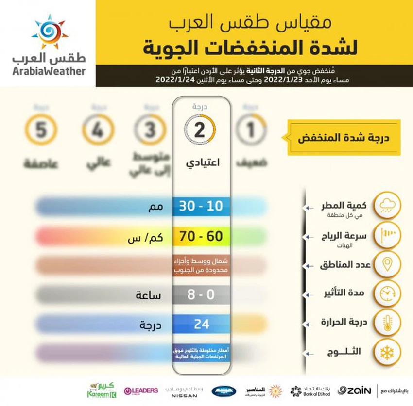
- Low degree: 2
- Rainfall: 10- 30 mm
- Wind gusts speed: 60-70 km/h
- Affected areas: North, central and limited parts of the south
- Temperature: 0 to 8 degrees Celsius
- Duration: 24 hours
- Snow: rain mixed with snow over high mountain elevations
For more news, download the Arabia Weather app from here
God knows.


Arabia Weather App
Download the app to receive weather notifications and more..