Jordan | Details of an air depression, which was classified as a third degree, affecting the Kingdom during the coming days

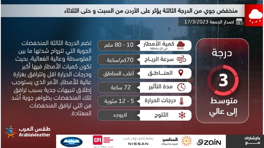
Arab Weather - Weather forecasters at the Arab Regional Weather Center said that the upcoming depression in the Kingdom has been classified as a third degree (according to the depression intensity index), and it is accompanied by a cold and moist air mass. This depression affects the Kingdom gradually, starting from Saturday afternoon and continues until the hours of the day on Tuesday.
Jordan is affected by the introduction of the depression on Saturday 3-18-2023
And in the details, it is expected that Jordan will be affected on Saturday by the introduction of the depression centered superficially over the island of Cyprus, and this introduction will lead to the multiplication of clouds at different altitudes in the afternoon and evening hours, and showers of rain will fall in parts of the north and center of the Kingdom, It may be accompanied by the occurrence of thunder at times, and a decrease in temperatures occurs and the speed of dust-raising winds gradually activates in the desert areas, and relatively cold weather prevails in general in most regions.
During the night hours (Saturday / Sunday night), temperatures drop compared to previous nights, and the weather is cold in various regions, with clouds continuing to appear at different heights, and the opportunity remains ripe for local showers of rain, especially in parts of the eastern desert.
An air front crosses the kingdom at dawn and Sunday morning
According to the weather maps in the Arab Regional Weather Center, the depression, classified as a third degree, is moving superficially to the northeast of the island of Cyprus, and the Kingdom gradually crosses a cold air front during the dawn and morning hours of Sunday 3-19-2023, so that a noticeable drop in temperatures occurs and becomes less than Its rates for this time of the year are about 4-6 degrees Celsius, and the weather is cold over the high mountain elevations and relatively cold in the rest of the regions, and fluctuates between partly cloudy and cloudy, and showers of rain fall, God willing, in the north and center of the Kingdom, and It is not excluded that it will be locally heavy, and the winds will be active from the west to the southwest at an active speed, accompanied by strong gusts at intervals of about 60-70 km / h, and they will cause dust and dust in the desert areas.
And during the night hours (Sunday / Monday night), the weather continues to be cold in most regions, and the opportunity remains ripe for intermittent rain in parts of the north and center of the Kingdom, as rain extends to some southern regions.
The depression deepened in the late night hours and dawn on Monday, and a new air front crossed the kingdom
The effect of the third-degree depression, which is attached to the cold and moist air mass, deepens, as it is expected that a new air front will form and cross the Kingdom’s airspace with the late night hours and dawn of Monday 3-20-2023, so that rain will renew in many northern and central regions. It extends towards the southern heights sometimes. These rains are heavy at times and may be accompanied by showers of hail at times, with fog forming over the high mountain heights as a result of the crossing of low clouds touching the surface of the earth.
And the effect of this depression increases during the day of Monday, so that more decreases occur in temperatures, and they are colder than their usual rates, within the range of 5-7 degrees, and the weather will be cold over the high mountain heights, and relatively cold in the rest of the regions, and it is expected, God willing. Precipitation falls in the north and center of the Kingdom and some southern and eastern regions. And these rains are sometimes heavy and accompanied by showers of hail, which leads to the flow of valleys and reefs, in addition to the rise in the water level in some areas.
As for the evening and night hours, Monday / Tuesday, the depression gradually moves away from the region, as the weather activity gradually weakens, and the weather is cold, with sporadic showers of rain falling in some areas, especially parts of the center and south of the Kingdom.
Recommendations from the Arab weather:
Pay attention to the dangers of torrential rain and valley run-off on Sunday and Monday.
Pay attention to the dangers of low horizontal visibility as a result of the formation of fog over the high mountain heights
Warmer clothes are recommended.
Safe use of heating methods in conjunction with low temperatures.
God knows.


Arabia Weather App
Download the app to receive weather notifications and more..