Jordan: Upgrading the classification of the depression expected tomorrow to the third degree, due to the expected significant impact on the south of the Kingdom

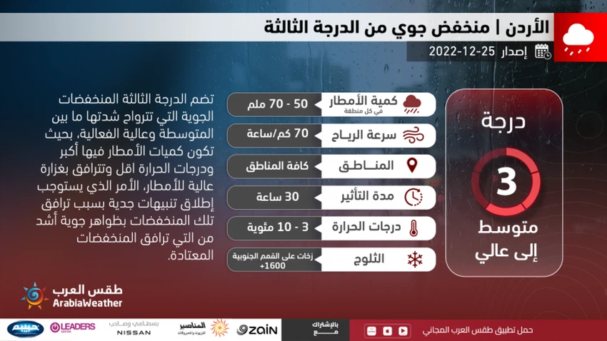
Arab Weather - The regional "Arab Weather" Center for Meteorology and Weather Forecasts announced that the classification of the upcoming depression has risen to the third degree (medium to highly effective), according to the innovative scale for classifying depressions in Jordan . And weather forecasters in the operations room of the "Arab Weather" center stated that the depression had been raised to the third degree due to the large expected effects on the south of the Kingdom, and this depression is also distinguished in that it affects all regions of the Kingdom, God willing, and they do not expect further development of this depression So that it remains within the category and the third degree. It is expected that the depression will bring good amounts of rain that will contribute to raising the rainy reserves of the Kingdom and in the agricultural sector, God willing.
And in the details, it is expected that the weather will be remarkably cold in various regions of the Kingdom tonight (Sunday / Monday), with the gradual appearance of clouds at different heights, and the opportunity is gradually created, starting from midnight and Monday dawn, for showers of rain in some areas, Fog also forms over the mountains as a result of the crossing of clouds touching the surface of the earth, and the winds are southwesterly moderate in speed, sometimes brisk, and this comes in the context of the Kingdom being affected by the front of the depression.
And the latest weather readings analyzed by the Arab Weather Center indicate that it is expected that the effect of the third-degree depression will deepen on Monday, which is attached to the cold and moist air mass, as it is expected that an air front will form and cross the Kingdom’s airspace as we enter the first hours of the day, so that it will be The weather is cold, with rains, God willing, starting from the northwest of the Kingdom, which will soon spread, God willing, to most regions of the Kingdom, and the rains are sometimes heavy and are accompanied by the occurrence of thunder and heavy showers of hail. It is not excluded that large amounts of rain will be recorded in the southern regions of the Kingdom, which in some areas may exceed 60 mm, which leads to the formation of torrents and the flow of valleys and reefs, in addition to the rise in the water level in some areas.
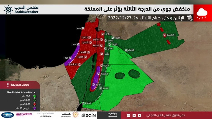
And as we enter the evening and night hours (Monday/Tuesday), the weather is expected to be cold in various regions, and even very cold over the high mountain heights, and the rain is then concentrated in the south of the Kingdom and is sometimes heavy and at an almost continuous pace, as it warns of high The water level in the roads and also the flow of the valleys, while the precipitation becomes more distributed in the north and center of the Kingdom and at intervals. And low clouds touching the surface of the earth pass over mountain heights, especially the high ones, which leads to the spread of fog and low horizontal visibility, whether on Monday-Tuesday night or Tuesday morning.
Recommendations from the Arab weather to deal with this depression
And due to the high classification of this depression and its reaching the third degree, the Arab weather calls for attention to the following matters during the impact of this depression:
- The danger of strong wind speeds, whose gusts exceed the 70 km/h mark. Therefore, it is advised to install collectibles on the roofs of buildings and external properties for fear of falling.
- The danger of heavy rains and their continuation, especially in the southwest of the Kingdom, and therefore it is advised to stay away from the streams of valleys, torrents, reefs and slopes, in addition to avoiding crossing roads where the water level rises.
- Safe use of heating methods in conjunction with low temperatures.
- The risk of low horizontal visibility over mountain heights, especially high ones, as a result of fog resulting from the crossing of clouds and low clouds touching the earth's surface.
God only knows.


Arabia Weather App
Download the app to receive weather notifications and more..