Latest developments: Tropical Cyclone Tej is getting stronger, and the Sultanate of Oman and Yemen are within the sphere of influence, with fears of sweeping flow of valleys and floods in the coming days.

Arabia Weather - The Arab Weather Regional Center for Weather Forecasts issued on Saturday evening, 10-21-2023, the latest details regarding the tropical weather condition located southwest of the Arabian Sea.
Remote sensing observatories and the latest satellite images at the Arabian Regional Weather Center show that the tropical condition is classified as a first-class hurricane, with wind speeds around the center estimated at approximately 64 to 82 knots (118-151 km/h), and it is approximately 64 to 82 km/h from the coast of the Arabian Peninsula. Approximately 600 kilometers.
The analyzes of specialists at the Arabian Weather Center indicate that the tropical condition will continue to move to the northwest and west during the next few days, with the possibility of it deepening into a second-degree hurricane, with its direct effects on some governorates of the Sultanate of Oman and Yemen beginning on Monday and Tuesday, October 23 and 24. .
This means that the tropical condition has reached hurricane status, meaning that it is accompanied by very heavy rains and strong winds, in addition to high waves, which may submerge some coastal and low-lying areas.
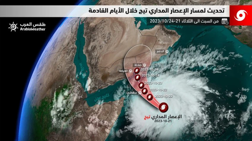
Forecast of the tropical state's path in the coming days
According to the future computer simulation of the movement of this tropical condition, which is operated within the Regional Arabia Weather Center, it is expected to move to the west and northwest during the coming days as it deepens into a second-degree hurricane, and it is also likely to cross between the Yemeni and Omani borders on Tuesday. .
- Sunday, October 22: The tropical condition continues to be classified as a first-degree hurricane and is likely to develop into a second-degree hurricane later in the day, with the beginning of its indirect effects on the coasts of the Dhofar and Al-Mahra governorates during the night hours, in the form of a flow of clouds at different altitudes accompanied by rainfall. The intensity varies with the possibility of rising water levels and flowing into valleys and reefs in some areas. The wind speed also increases at intervals with rising waves on the coast of the Arabian Sea, reaching a maximum height of about 5 metres, and the possibility of sea water spreading to some low-lying areas.
- Monday, October 23: The tropical condition deepens into a third-degree hurricane, and its direct effects begin on the governorates of Dhofar and Al-Wusta, in addition to Al-Mahra and parts of Hadramaut in Yemen, and are accompanied by high-speed winds and heavy rains ranging in quantity from 100 to 300 mm, leading to flowing valleys. There may be severe flooding of the valleys, and the sea will be very rough on the coasts overlooking the Arabian Sea, and its maximum height will range from 5-8 meters as sea water levels rise and penetrate into the land in low-lying areas.
- Tuesday, October 23: The tropical status classification declines to a first-class hurricane as it gradually crosses the border areas between Yemen and the Sultanate of Oman (but this requires further follow-up due to the possibility of changing the transit center). The tropical status is accompanied by very fast winds and very heavy rains. Its quantity ranges from 150 to 600 mm, leading to severe valley flooding in parts of the Dhofar and Al-Mahra governorates, in addition to parts of Al-Wusta and Al-Mahra.
God knows best and highest.


Arabia Weather App
Download the app to receive weather notifications and more..