Monitoring the formation of a deep depression now between Italy and Greece, accompanied by strong winds, heavy rains, and indirect effects of the depression on an Arab country.

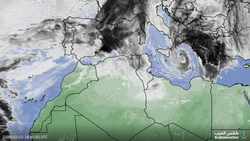
Arabia Weather - The latest images taken recently from the remote sensing systems of the Arab Regional Weather Center monitor the formation of a deep depression, which is currently centered over the Ionian Sea between the Italian islands and Greece, and around its center dense bundles of cumulonimbus thunderclouds carrying heavy rains coincide with the blowing of high-speed winds. According to the latest readings, its speed has reached approximately 80 km/hour, and the gusts exceed that much, causing severe disturbance of the waves within the framework of the position of this depression.
The depression will deepen further tonight and Monday morning and will directly affect Greece
Weather forecasters at the Arab Regional Weather Center said that the latest thing that computer numerical simulation models indicate is the occurrence of further deepening and development of this air depression during the hours of tonight, dawn and Monday morning, coinciding with its movement eastward towards Greece, where the direct effects of this weather system on areas will be A wide area of Greece, especially its southern parts. It is expected, God willing, that the depression will cause the movement of dense bands of cumulonimbus clouds accompanied by heavy to very heavy rains, accompanied by strong thunderstorms and heavy hail showers, which will raise the possibility of floods and a rise in water levels. High-speed winds, with gusts reaching approximately 120 km/hour, cause severe turbulence in the sea waves, reaching wave heights of 3-5 metres, especially at depth.
It is expected that between Monday night and Tuesday day, the severity of the depression will ease and its effects will then be concentrated on the southwestern regions of Turkish territory, accompanied by active winds and rain, God willing.
Indirect effects of the weather system on northern Libya in the form of strong winds and occasional rain showers
During the crossing of the depression tonight and Monday, it is expected that the northern Libyan territories will be affected by indirect consequences of the weather system in the form of strong winds blowing on the northern coasts, specifically Benghazi and its environs, with a clear disturbance in the waves of the Mediterranean Sea near the coasts and in the depths, and showers are not excluded. Scattered rain in parts of the coastal region as a result of some rain clouds passing from time to time.
The depression results from the rush of a very cold air mass towards the waters of the Mediterranean Sea and does not acquire any subtropical characteristics.
The weather forecast staff at the Arabia Weather Center confirmed that the depression now present over the sea waters does not acquire any sub-tropical characteristics, but rather resulted from the rush of a very cold air mass towards the waters of the Ionian Sea (which is considered part of the Mediterranean Sea) and due to the sharp thermal differences between the air The cold coming from the European continent and the warmer sea water surface temperature form the air depression according to God’s will.
Satellite images show a dragon-like depression in the central Mediterranean
God knows.
ArabiaWeather Company shall not be responsible for any republication. The materials published in the “Arabia Weather Blogs” in the various media, which puts anyone who publishes these blogs in the name of the Arabia Weather or quoting the Arabia Weather under liability and legal accountability.


Arabia Weather App
Download the app to receive weather notifications and more..