Saudi Arabia: Chances of thunderstorms continue in several regions of the Kingdom during the last days of Ramadan

Weather of Arabia - The latest weather maps, resulting from the so-called computer simulation, indicate expectations that the Kingdom of Saudi Arabia will continue to be affected in the coming days by air disturbances. As a result of the passage of an upper wave over the Kingdom's airspace, coinciding with the flow of tropical water vapor from the south, so that cumulus clouds multiply in the afternoon and evening hours, and thunderstorms fall in many areas, God willing.
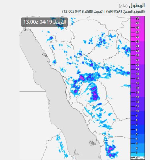
Wednesday: the expansion of the cumulus rain clouds to include several parts of the west, center and north of the Kingdom
And it is expected, God willing, that the activity of cumulus clouds will renew in the afternoon hours of Wednesday over large parts of the western sector, to include the heights of Asir, Al-Baha, Makkah Al-Mukarramah and the eastern parts of these areas, in addition to large parts of the Medina region, and these clouds are accompanied by Medium rains that may be interspersed with some heavy spots at times and are sometimes accompanied by the occurrence of thunder.
It is not excluded that some cumulus clouds extend to separate parts of eastern and southern Tabuk, Al-Jawf, west of the northern border, Hail and Al-Qassim, but very randomly.
Rainy cumulus clouds extend gradually during Wednesday to several parts of the Riyadh region administratively, especially the western governorates (including Afif, Al-Dadmi, Shaqra, Al-Quwaiyah, and the neighboring governorates), and gradually reach the capital, Riyadh, God willing.
Chances of thunderstorms include most regions of the Kingdom during the last days of the holy month (astronomically)
And the area of activity of the cumulus rain clouds expands additionally on Thursday, which coincides with the last days of the month of Ramadan (astronomically), so that the cumulus clouds multiply again in different parts of the western sector and gradually extends to several parts of the central and some northern regions.
At the same time, a less hot air mass is approaching the eastern basin of the Mediterranean Sea, as the northwest wind gradually activates with the passage of Thursday in the northern and northwest regions, causing dust and dust in those areas, especially on desert roads.
God knows.


Arabia Weather App
Download the app to receive weather notifications and more..