Saudi Arabia | Illustrative maps of rain forecasts and areas most affected by the rainy situation on Thursday, 21/4/2022 AD

Arab weather - Sinan Khalaf - large parts of the Kingdom of Saudi Arabia will be affected on Thursday by the first day of the rainy situation and the series of weather fluctuations expected to affect the Kingdom in the remainder of this month of April, so what are the areas that will be covered by unstable weather conditions and rain for Thursday?
Thunder clouds accompanied by scattered winds and dust
Saudi regions covered by rain and weather fluctuations for Thursday
In the details, the latest outputs of the computer simulation systems for rain forecasts indicate that large parts of the Kingdom will be gradually affected on Thursday by unstable weather conditions, starting after God’s will during the day on the western heights of the Kingdom and its eastern slopes, and extending with the afternoon and evening hours towards random parts of the Riyadh region. Administratively, Qassim and Hail, and the area of rain expands on Friday and includes the heights of Jazan, Asir, Al Baha, Makkah, Madinah and its eastern slopes, in addition to random parts of the administratively Riyadh, Hail and Qassim region, with an opportunity to extend some rainy clouds to the northern sector of the Kingdom.
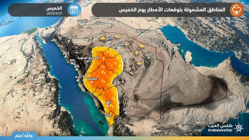
Regarding the intensity of the expected rain, it is expected to be moderate in general with some heavy foci in narrow geographic ranges, working on the flow of valleys and torrents, which may be accompanied by hail showers, and the activity of downward winds that raise dust and dust, which means a high probability of low horizontal visibility and perhaps its absence due to the dust.
And weather forecasters added that the weather conditions during this period of the year in particular are distinguished from others by the departure of the bases of cumulus clouds from the surface of the earth, as a result of the drying out of the lower layers of the atmosphere, and this means the evaporation of part of the rain before it reaches the surface of the earth, and this leads to the occurrence of cooling/decrease In the temperatures inside the cloud, the density of the air rises, and it becomes heavier in weight compared to the surrounding air, then it rushes strongly and hits the surface of the earth directly. Especially in desert areas.
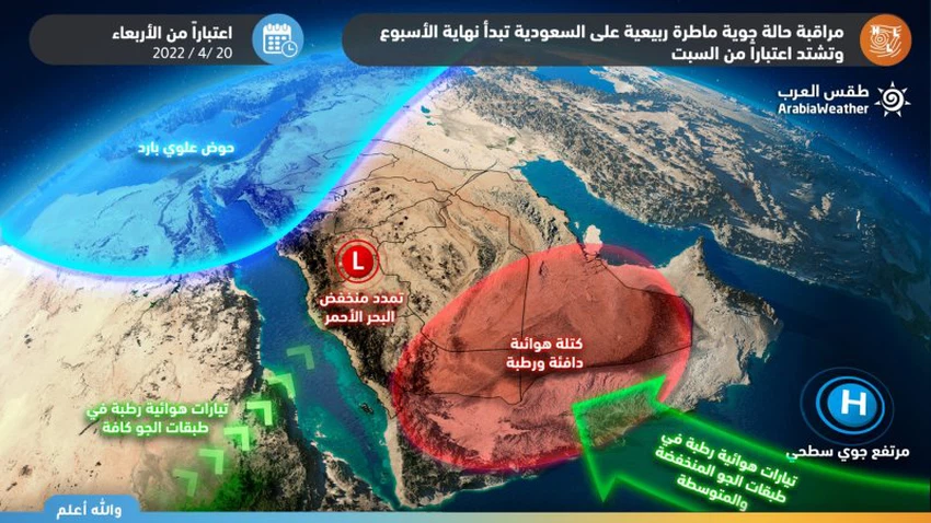
Thunderstorms intensifying and widening Saturday
The cold upper basin deepened into the kingdom on Saturday and Sunday
The outputs of the computer processing in the Arab Weather Center indicate expectations that the upper cold basin will deepen the Kingdom’s atmosphere on Saturday and Sunday 23 and 24 April 2022, coinciding with the blowing of warm and humid air currents from tropical shows, and the displacement of the subtropical air high from the atmosphere of the region, which leads to an expansion The intensification of unstable weather conditions in light of a superficial response to the Red Sea depression, clearly and effectively. This system works to raise the power of rain and intensify the intensity of thunder clouds on the mountainous heights and eastern slopes located in the west of the Kingdom, and the extension of rainy clouds to include large parts of the Kingdom, God willing.
The science behind this air turbulence
These expected atmospheric disturbances come due to a combination of a shallow drop in atmospheric pressure and a dynamic contribution to the vertical thermal difference and a superficial response as well as to the Red Sea depression effectively, which also works to excite warm and humid air currents from tropical latitudes. The presence of temperature differences of up to 30-35 degrees Celsius, and perhaps more, between the surface of the earth heated by solar radiation and the cold air located at the top is the first condition for the condensation of cumulus clouds, and the extent/quantities of water vapor extension towards the Kingdom’s atmosphere is an important condition as well. To ignite these thunderclouds, which is something that numerical models find very difficult to sense until now, so the computer modeling outputs still fluctuate around the intensity of the rainy condition.
Therefore, all of the above is considered within the context of the forecasts of the latest weather readings issued by the Arab Regional Center for Meteorology and Forecasting, so updates will be released that will highlight more details incrementally whenever needed, God willing.


Arabia Weather App
Download the app to receive weather notifications and more..