Saudi Arabia Monthly Bulletin | A clear cold and chances of rain are concentrated in the second half of November and will include these areas
Monthly weather forecast for the Kingdom of Saudi Arabia
A cold month, and chances of rain are concentrated in the second half of November, and may include Riyadh
Note: It is strictly forbidden to transfer this information, data and the weather forecast, to publish it on social media and others, and/or to dispose of it in any way without the prior and written consent of Arab Weather, under penalty of legal accountability.
ArabiaWeather - offers you ArabiaWeather monthly bulletin weather forecast for the month of November 2021.
October 2021 issue .
The issuance of these forecasts depends on studying the behavior of temperature and atmospheric pressure in the northern hemisphere, including the atmosphere and major water bodies, and integrating those forecasts with global monitoring centers, to come up with the highest possible forecast.
Arab weather experts in the Department of Scientific Research and Development have developed scientific methods that are considered the first of their kind in the Arab world and the world, as they depend on artificial intelligence in forecasts for the coming months, by developing complex mathematical algorithms and equations to detect the behavior of the atmosphere and correct long-range weather forecasts.
Unlike the daily weather bulletin, these bulletins focus on listing the general weather during a month, where the aim is to know the deviation of rainfall and temperatures from their general rates. Many meteorologists in the world are busy trying to decipher the mystery of making accurate seasonal forecasts by conducting many researches in this regard, in which the Arab Weather team participates in part.
The desired benefit of the quarterly bulletins lies in assisting various sectors in the early planning for the fall and winter alike, especially the agricultural sector, which builds its agricultural plans on these indicators that sometimes help to reap and achieve profits by exploiting this information, in addition to many other sectors that Benefit from these forecasts, such as the commercial sectors, the apparel sector, the energy sector and others.
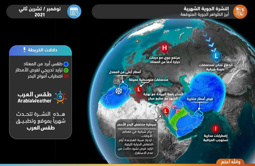
General situation
- Extension of the Siberian High at the end of the month, warning of frost formation in Iraq and northern Saudi Arabia and the harmful impact on the agriculture and livestock sector
- Gradual improvement in the chances of rain in the second half of the month in different areas, God willing, and by observing the formation of 2-3 cases of instability associated with the proliferation of convective clouds and precipitation of varying intensity, accompanied by thunder and dust sometimes
- Chances of rain improved in Al Wusta, including Riyadh, Sharqiya, and the State of Kuwait, especially during the last third of the month.
- The chances of rain and its intensity improved in the western region at the end of the third week of the month
- Great cold weather is expected in the third week and significantly at the end of the month, which raises the energy bill and the need to wear warm clothes in large areas, including Riyadh,
- Warning against the spread of colds / colds and seasonal diseases in the last third of the month due to the clear cold weather.
- The weather is colder than usual in the Emirates and the Sultanate of Oman for most of the month.
- Observation of 1-2 tropical states, centered on the central and eastern Arabian Sea.
Weather forecast for this month
general air systems

temperature forecast

rain forecast

The most important weather phenomena expected this month
Special weather for each week
First week (November 1-7, 2021)
|
Region |
temperature forecast |
rain forecast |
Recommendations |
|
middle of Saudi Arabia |
About below average |
nothing |
|
|
northern Saudi Arabia |
About above average |
scattered showers |
|
|
southern Saudi Arabia |
Below average |
scattered showers |
|
|
Eastern Saudi |
about average |
No significant rain |
|
|
western Saudi Arabia |
above average |
No significant rain |
|
General forecast for the week
- It is expected that the depressions over northern Russia and Europe will deepen significantly during this period in conjunction with a weakening in the strength of the Icelandic depression, which leads to the rush of cold air from the North Pole towards the southwest of the European continent and central Asia, leaving northern Arabia, eastern Europe, northern Egypt and the countries of The Levant is under the control of the subtropical high altitude.
- This results in a significant weakness in the chances of rain in several parts of the Arabian Peninsula, with the exception of its southeast, due to the extension of some cold air basins across Iran.
- The weather is also warmer than usual in the whole of the north and west of the Arabian Peninsula, and the temperature decreases and the weather becomes colder than usual, especially in the south and southeast of the Arabian Peninsula.
Second week (November 8-14, 2021)
|
Region |
temperature forecast |
rain forecast |
Recommendations |
|
middle of Saudi Arabia |
Below average |
Showers in the north of the region |
|
|
northern Saudi Arabia |
about average |
thunder showers |
|
|
southern Saudi Arabia |
Below average |
showers |
|
|
Eastern Saudi |
Below average |
showers |
|
|
western Saudi Arabia |
About below average |
showers |
|
General forecast for the week
- The polar vortex is expected to activate in northern and northeastern Russia, in conjunction with a remarkable rise in atmospheric pressure on northern and western Europe, which leads to the concentration of cold air rushing towards parts of northeastern Europe and down to the central Mediterranean, while it is expected that the semi-atmospheric high will weaken The tropics shift from the north of the Arabian Peninsula, paving the way for a relative improvement in the chances of reaching relatively cold air masses towards Egypt and northwestern Arabia.
- This leads to an improvement in the chances of rain relatively on the north and west of the Arabian Peninsula and may affect the north of the central region in Saudi Arabia, with the chances of rain still appearing in the Sultanate of Oman and Yemen.
- It is expected that the weather will remain colder than usual in all southern regions of the Arabian Peninsula, with an increase in the area of colder than usual conditions to include different regions with varying severity, except for the coasts of the Red Sea.
Third week (November 15-21, 2021)
|
Region |
temperature forecast |
rain forecast |
Recommendations |
|
middle of Saudi Arabia |
Below average |
Special showers in Hail |
|
|
northern Saudi Arabia |
About below average |
thunder showers |
|
|
southern Saudi Arabia |
Below average |
thunder showers |
|
|
Eastern Saudi |
Below average |
scattered rain showers |
|
|
western Saudi Arabia |
Below average |
thunder showers |
|
- Atmospheric pressure is expected to rise in important areas of the Arctic, including the island of Greenland, in conjunction with the control of air heights over northwestern and western Europe, which means the activity of the polar cell and stronger refraction of air jets above the atmosphere, and this leads to the rush of cold air masses from the north towards South in the form of air basins closed / cut basins (cut-Off) activity depressions offers medium - sized central and Eastern Europe.
- It is expected that the Arabian Peninsula will be affected by the first unstable weather condition that will bring cumulus clouds and rain showers, God willing, especially in the northern and western regions.
- The weather remains colder than usual in most areas, with the need to wear a coat and warm clothes at night in the northern regions and some central regions.
Fourth week and rest of the month (November 22-30, 2021)
|
Region |
temperature forecast |
rain forecast |
Recommendations |
|
middle of Saudi Arabia |
Below average |
Showers, may include the city of Riyadh |
Warning of the formation of water bodies |
|
northern Saudi Arabia |
Below average |
showers |
|
|
southern Saudi Arabia |
Below average |
showers |
|
|
Eastern Saudi |
Below average |
showers |
Opportunities for the formation of water bodies in the west |
|
western Saudi Arabia |
Below average |
showers |
Opportunities for the formation of water bodies in the east |
General forecast for the week
- The chances of atmospheric depressions extending into the high layers of the air over the eastern Mediterranean and northern Arabia continue, but with a gradual weakening and increasing activity of the polar cell (the dominance of atmospheric heights), which leads to a noticeable intensification in the depressions of the middle latitudes on the European continent, in addition to a significant weakening in the strength of the Icelandic depression. With the concentration of cold and rainy activity on the central and western Mediterranean and the north of the African continent,
- The formation of 1-2 rainy cases of varying intensity is observed over parts of the Arabian Peninsula during the last third of the month, which may include the city of Riyadh in one of them, God willing, and it is expected that the chances of rain will improve in the Eastern Province.
- At the end of the month, the Siberian air rise intensifies over parts of Russia and Central Asia, with its extension towards Iran and parts of northern Arabia, and this means gradual stability on the weather, with a noticeable increase in the coldness of the weather at night and the high chances of frost occurring in Iraq and parts of northern Saudi Arabia during the night. Late and early morning.
Climatic situation (for professionals and those interested)
The Arctic Dome and the North Atlantic
It is expected that the positive pattern will prevail on the Arctic Oscillation in the first third of November, followed by a decrease in values to complete the rest of the month in a negative pattern, in conjunction with a wire almost similar to the North Atlantic coefficient, which means a high persistence of high atmospheric pressure values over parts of the North Pole, especially the areas Northeast America and Northeast Europe.
This results in a remarkable activity of cold masses in the northwestern and central parts of the European continent, all the way to parts of southern Europe and the northern Maghreb countries.
These weather conditions lead to the rush of the cut basins (cold closed air masses) to the south more than usual, i.e. towards semi-tropical widths, including the Mediterranean basin, which increases the chances of developing Mediterranean storms in the central part between Greece and Italy and the coasts of Libya, Tunisia and Algeria.
It is expected that the Siberian high altitude will intensify over parts of western Russia and eastern Europe at the end of the month, which will lead to cold weather at night and the extension of frost opportunities to the north of the Arabian Peninsula and parts of the Levant.
Tropical Pacific Ocean
The equatorial region of the Pacific Ocean will witness a dominance of the La Niña phenomenon during the coming period, which means that surface water temperatures during the past three months are lower than the general averages with a deviation of more than 0.5 degrees, especially in the eastern Pacific Ocean.
As a result, subtropical air heights dominate (from time to time) over the north of the Arabian Peninsula and Egypt, coinciding with rising amounts of rain over the central and western Mediterranean, and remarkable activity of the Atlantic and western Pacific hurricane seasons, and the activity of the northern Indian Ocean hurricane season near India. .
Indian Ocean and Arabian Sea
The Indian bipolar coefficient is expected to rise, i.e. the negative pattern will end, and it will move to a neutral pattern during the coming period, which is the result of a rise in surface water temperature in the Arabian Sea and the northern Indian Ocean.
This results in a relative improvement in the chances of the emergence of tropical weather conditions in the Arabian Sea, an increase in the amount of water vapor entering the Arabian Peninsula, and the emergence of unstable weather conditions and precipitation, God willing, if there is an air depression in the high layers of the atmosphere in the north of the Arabian Peninsula.
God knows


Arabia Weather App
Download the app to receive weather notifications and more..