Scientific reading: Storm Daniel’s journey from Greece until its arrival in Libya and its devastating effects will not be forgotten

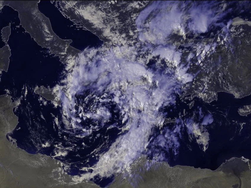
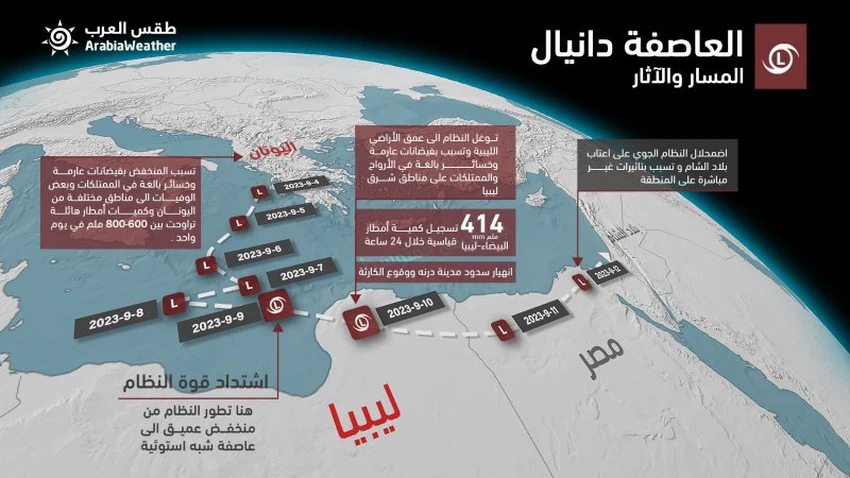
Arabia Weather - A focus of low air pressure formed on the fourth of September in the middle of the Mediterranean Sea and caused large amounts of rain to fall on parts of the Balkan countries, including Greece, in addition to western Turkey and the city of Istanbul, and the amounts of rain exceeded the barrier of 800 mm. In some Greek areas, this led to floods, causing many deaths, and these quantities were described as unprecedented in those areas and the strongest storm to hit Greece since 1930.
The depression developed into a storm before hitting Libyan territory
Between the eighth and ninth of September, the weather system known as Storm Daniel developed and acquired tropical characteristics in that wide sea area located between the island of Crete and the coasts of Libya and Italy, which is characterized by warm sea water, as a result of the continued flow of cold air. In the high atmosphere of the central Mediterranean, coinciding with another hot air rush from the south.
These tropical characteristics appeared on the ground in the form of a noticeable increase in atmospheric turbulence from the intensity of thunderstorms, in addition to an increase in the speed of wind rotation and currents around the center of the depression, which made the depression appear in a shape similar to tropical systems from satellite images.
Storm Daniel struck the eastern Libyan coast on the morning of Sunday, September 10, 2023, and continued to have an impact on Monday. It was accompanied by stormy wind gusts accompanied by extremely heavy rains, leading to devastating floods that swept entire neighborhoods, killing thousands, and destroying... Many homes, properties, and facilities in several coastal cities in the east of the country, such as Derna, Al-Bayda, Al-Marj, Shahat, and Sousse, in addition to towns and villages in the region.
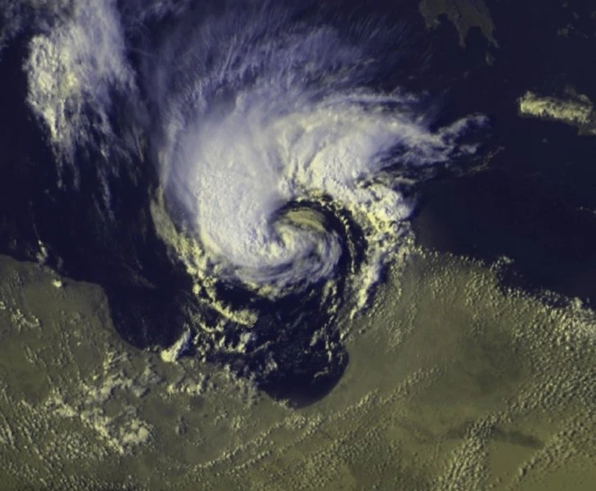
It can be seen from the attached image that the atmospheric system has acquired tropical characteristics in the form of assuming a rotational position around the center of the depression and forming a closed eye
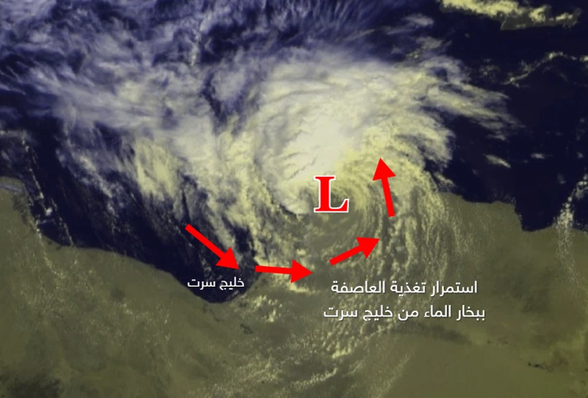
Although Storm Daniel quickly penetrated the Libyan mainland, this did not prevent its severe impact, and it did not lose its strength and momentum, because it received continuous nourishment coming through a sea breeze from the Gulf of Sirte, in addition to the significant warming of the water body.
This enhanced the longevity of these severe cumulonimbus cells accompanying the storm by affecting eastern Libya for a long period.
The collapse of two water dams made the impact disastrous!
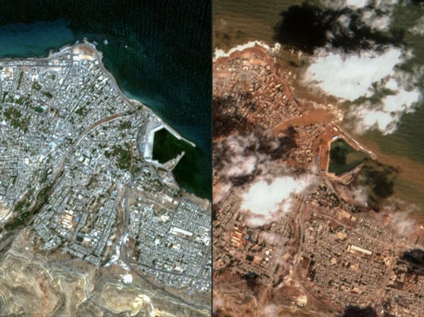
But the real disaster was in the city of Derna. Where the Great Wadi Derna Dam is located, the enormous pressure of the water caused the collapse of the Great Wadi Derna Dam, and the second dam soon joined it. The topographic nature of the city of Derna also made the situation worse, as behind the very narrow strip of coastal land there is a mountain plateau that rises sharply. Very large amounts of rain poured from the mountain highlands into the valley, doubling its destructive capacity. The floods besieged the cities in the narrow coastal strip, and the dams were no longer able to withstand the pressure, so vast areas were flooded with water in a very short time, and the number of victims reached more than 5. Thousands killed, along with thousands of missing and injured.
Egypt: The last stop for Storm Daniel
On September 11, the remnants of the Daniel weather system moved to the northwest of Egyptian territory, led by a dust storm that affected the north of the country and led to a decrease in the level of horizontal visibility. Rain also fell on some governorates without causing any obstruction to daily life.
Despite the dissolution of the surface system on the threshold of Palestine, the cold and humid air mass in the upper layers of the atmosphere accompanying the atmospheric system moved from west to east towards the eastern Mediterranean and the Levant and led to a state of atmospheric instability that affected Jordan and Palestine on September 13, and brought showers of rain in random areas, while the impact was strong on the northern Gaza Strip and caused floods.


Arabia Weather App
Download the app to receive weather notifications and more..