Scientific reading: What is the polar vortex and what are the reasons for its splitting after God’s will?

Arab Weather - Weather experts at the Arab Weather Regional Center are following up on the latest numerical computer modeling indications about the possibility of a temporary warming in the stratospheric polar vortex, which, God willing, will cause a region of high atmospheric pressure to form above the Arctic Circle, and its reflection on the behavior of the polar jet stream and its impact on global weather patterns in the coming period.
What is the polar vortex?
The polar vortex is a circular system of cold air in the upper atmosphere that surrounds the North Pole. This vortex acts as a barrier that prevents cold air from moving south towards warmer, temperate regions. This vortex is most cohesive in winter when the Arctic is very cold.
When the polar vortex is strong, air currents swirl tightly around the pole, keeping cold air trapped in that area. But sometimes, the vortex breaks or weakens, causing cold air to rush toward lower latitudes, causing temperatures to drop dramatically in many areas.
Sudden stratospheric warming causes strong surface high to form over Arctic
Weather experts at the Arab Weather Regional Center said that as a result of the weakness of the western polar winds above the Arctic Circle and the descent of polar air from the upper levels of the atmosphere close to the Earth's surface, a temporary stratospheric warming occurs in the Arctic region, which causes the formation of a strong high-pressure system above the Arctic Circle. As previously mentioned, the upper western winds are what contain the polar masses in the Arctic, and as a result of their weakness, they are unable to contain the polar air and keep it in its original home (the North Pole).
Stratospheric warming affects the polar vortex, causing changes in polar air distribution patterns, and directly affecting the movement of jet streams and weather patterns in various regions of the Northern Hemisphere. The high pressure caused by warming is expected to cause the dispersion of polar air masses, thus causing a break in the polar jet stream, causing the dispersion of polar air masses. Polar air masses are expected to be concentrated in the coming period over northern and eastern Europe, in addition to northeastern North America and Russia, where the aforementioned countries will be exposed to very cold polar waves and heavy snow with large thicknesses, with the bomb cyclone phenomenon expected to occur, especially in North America.
What causes the polar vortex to split?
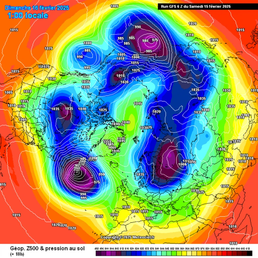
In this regard, weather experts at the Arab Weather Regional Center said that as a result of the formation of an area of atmospheric pressure above the polar vortex, a division/splitting occurs in the polar vortex, as we can see on the following map:
The Arab Weather Regional Center issued a detailed report through its official accounts stating the split of the polar vortex and its effects on the weather in the eastern Mediterranean basin region. You can view the report by clicking here.
And God knows best.


Arabia Weather App
Download the app to receive weather notifications and more..