Scientifically: How does the start of the polar vortex collapse affect the shift in weather patterns with the advent of spring

Weather of Arabia - The polar vortex is a very powerful driver of weather patterns during the cold season until the spring, and its effect extends from the lower layer to the higher levels of the atmosphere in the stratosphere, and at this time of the year a strong collapse of the polar vortex begins in the higher levels of the atmosphere. This collapse event will translate into a shift in weather patterns over the coming weeks.
To understand the impact of this on the weather, we will first learn in a simple way what the polar vortex is , and why it is so important, and then we will analyze the latest developments and detail the climate changes related to the collapse of the polar vortex during the month of April and the summer season of 2022, according to (sever-weather europe).
The polar vortex and its effect on the weather of the northern hemisphere
As we approach autumn each year, the Arctic regions begin to receive less sunlight, and the cooling begins over the Arctic. But with lower polar temperatures, the atmosphere in the south is still relatively warmer as it continues to receive light and energy from the sun.
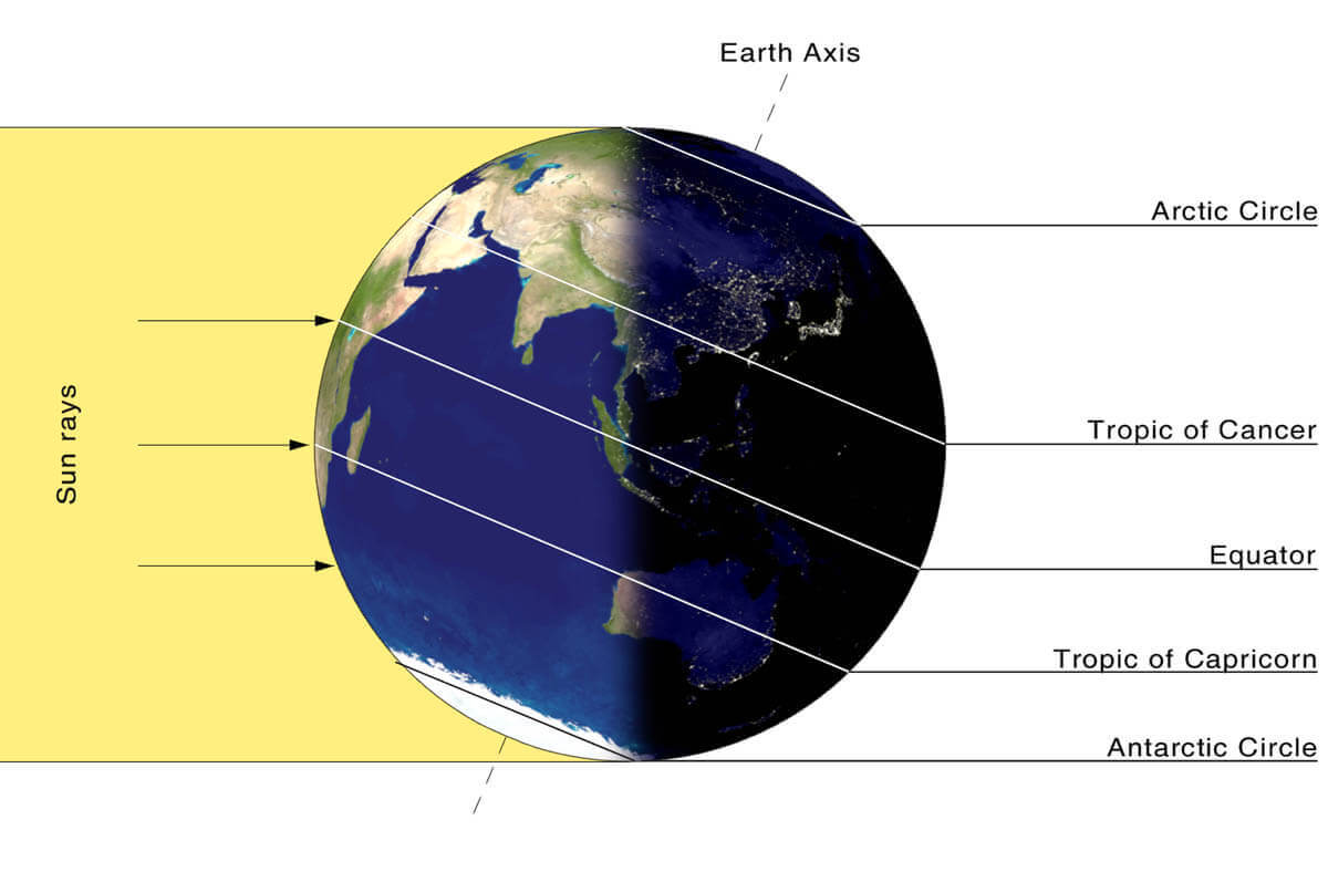
(The image shows the day of the winter solstice when the polar regions begin to receive very little solar energy compared to regions to the south, which still receive a lot of sunlight and energy.)
As the temperature decreases over the polar regions, so does the atmospheric pressure, so an increase in the temperature difference in the direction to the south creates a strong difference in atmospheric pressure on a large scale, and strong air circulation begins to develop around the lower pressure in the hemisphere. In the north, this rotation extends from the surface layers to the stratosphere, this rotation is known as the polar vortex .
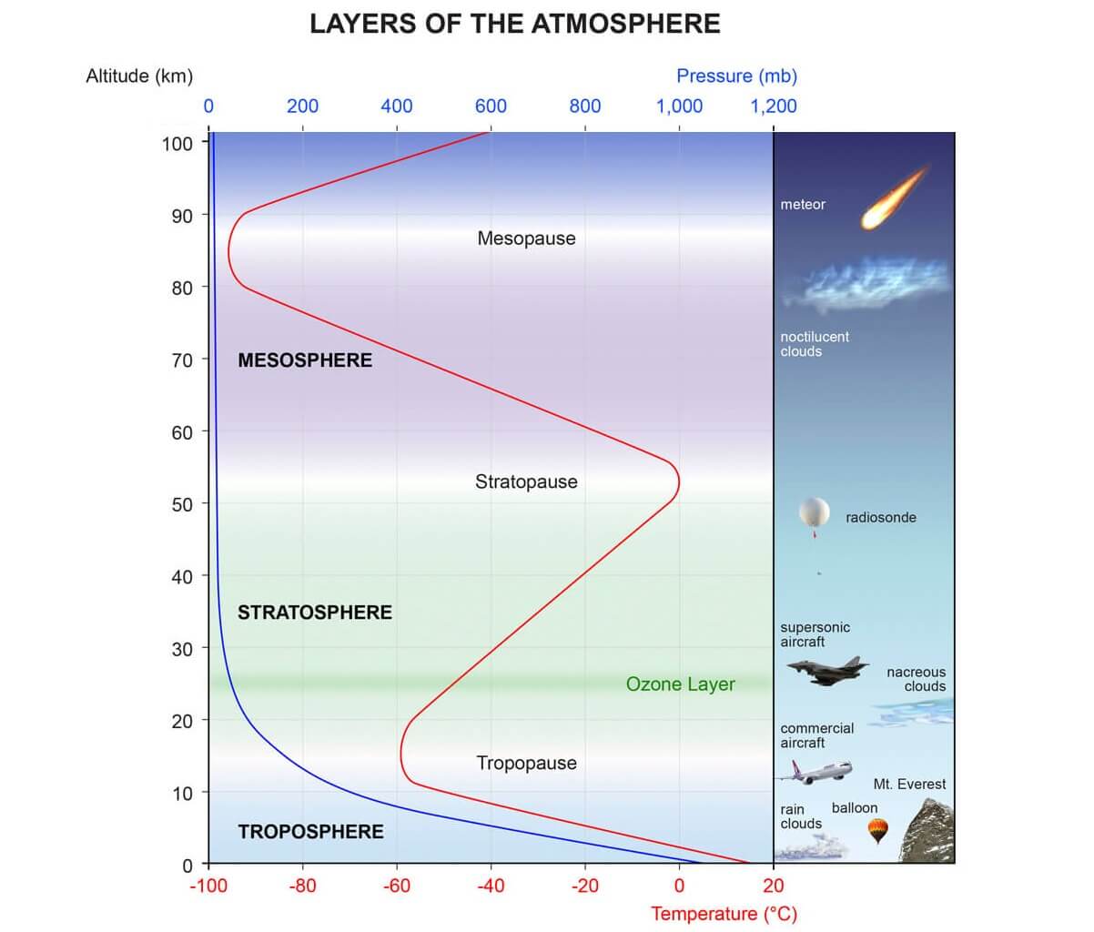
(The image shows the layers of the atmosphere, the troposphere (the blue layer) where changes in weather occur, and the stratosphere (the green layer) with the ozone layer above it)
Air circulation in the polar vortex is similar to a major hurricane that covers the entire North Pole, down to the mid-latitudes, and affects all levels of the atmosphere, to different degrees at different altitudes.
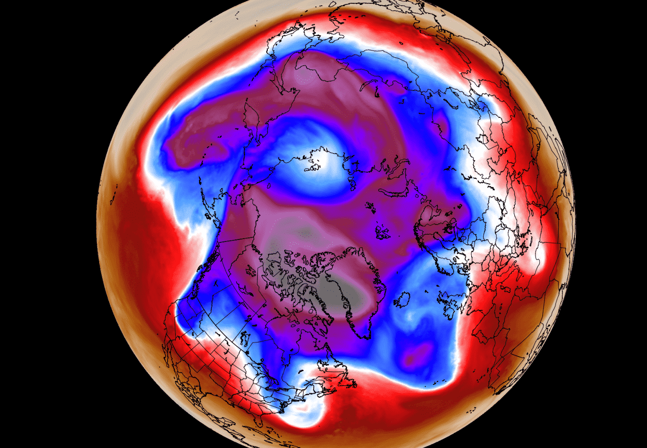
The image below shows a typical example of the polar vortex at peak strength during the winter at an altitude of about 30 km (10 mbar level) approximately in the middle of the stratosphere.

The following image below shows the polar vortex at a low altitude, about (5 km) and the closer to the ground, the greater the distortion of the polar vortex because the air in the vortex interacts with the mountains and general terrain and also with strong weather systems.
When the polar vortex is strong and the polar air circulation is strong, it traps this cold air in the polar regions and prevents it from escaping or extending toward the lower latitudes, creating milder weather for most of the United States and Europe (Figure below left).
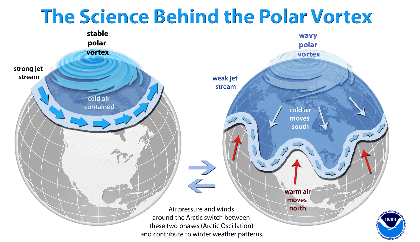
The weak polar vortex (undulating) creates very dynamic weather, as the vortex has more difficulty in containing cold air, causing it to escape from the polar regions in the form of “arms” extending to lower latitudes (right figure above), which leads to cold air and snowfall.
These arms also contain a lot of energy and can create powerful winter storms, such as Norrester in the United States or strong winds in the North Atlantic.
The polar vortex may be disrupted by high temperature and pressure in the stratosphere, an event called " sudden stratospheric warming ", which leads to the collapse of the polar vortex.
But there can also be smaller stratospheric warming waves that do not collapse the polar vortex, but shift or disrupt it enough to weaken its effect at near-surface levels.
Expectations of the collapse of the polar vortex during these days
The following video shows the upcoming collapse of the polar vortex, with a forecast of the 10 mbar (30 km) level, we can see a quick overview of the polar vortex as it splits first, followed by a strong displacement and a weakening.
1/ No blog today so here are some thoughts. #PolarVortex disruption/split is complete with major daughter vortex over Eurasia & minor daughter vortex over North America. In between the two is high pressure over the Arctic including Greenland in the polar stratosphere. pic.twitter.com/ZrZaW6LZ6m
— Judah Cohen (@judah47) March 21, 2022
The main result from the collapse shown in the video of the polar vortex is not just a single winter storm or cold air masses traveling from the Midwest to the northeastern United States, it is a large cyclonic region that rotates over the entire northern hemisphere, from ground level to the top of the stratosphere and above, So that it reaches a height of more than 50 km.
The end of the winter polar vortex
The level of 10 mbar is usually seen when analyzing the polar vortex in the stratosphere, i.e. at an altitude of about 28-32 km, this layer is considered to be in the middle of the stratosphere which shows the general strength and condition of the polar vortex in the stratosphere.
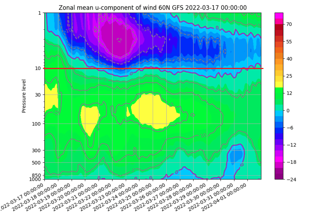
The strength of the polar vortex is often measured by the strength of the winds it produces, and this is done by measuring the speeds of the westerly winds (from west to east) around the Arctic Circle (latitude of 60 degrees north).
In the image below, we have the average monsoon transverse velocity of the polar vortex at the level of 10 mbar, the black line is the long-term average, and the blue line is the strength of the polar vortex in the winter season 2021/2022, we can see that in most of the winter season Cold, the polar vortex was stronger than usual .
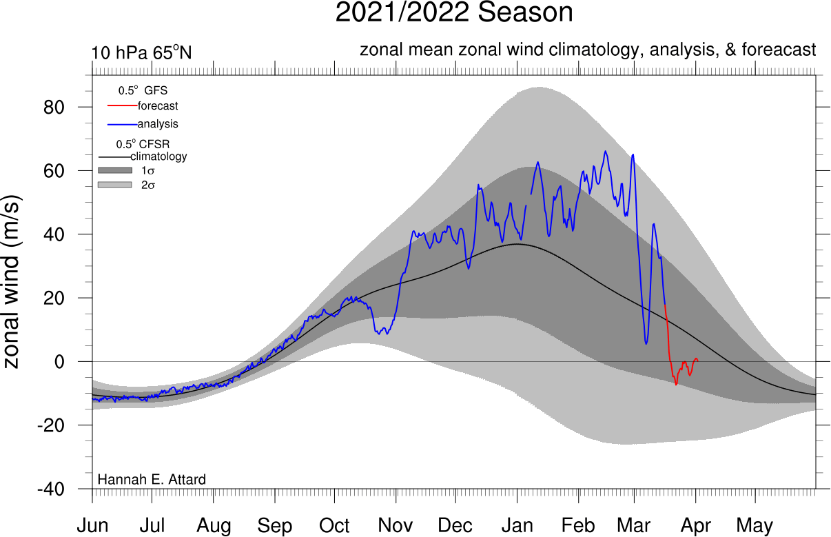
While the red line is the forecast, which indicates that the rapid weakening of the polar vortex is coming in the next few days, when the region's (westerly) winds drop below zero in a sharp and rapid event, this is considered as a collapse of air circulation.
Looking closely at the forecast portion (red line), the rapid decrease in westerly wind speeds appears in the stratosphere, as the polar vortex collapses and ends in the Arctic.

But not only the wind, the temperature is also of great importance. The colder the polar vortex, the more powerful it is, and also produces stronger winds. Below we have a 2021/2022 season analysis of stratospheric temperature at 10 millibars from NASA.

The red/violet line is the 2021/2022 season, which shows a cooler-than-normal polar vortex at 10 mbar in the stratosphere. But recently we can see an increase in temperature. Especially in the forecast segment (in orange), it will reach its highest levels, this is the beginning of the current stratospheric warming.
Of course, cooler temperatures and stronger winds mean less pressure, and this can be seen in the following image by the strong accumulation of low pressure in the stratosphere in late November, when the polar vortex was strong, all the way to surface levels in early December, and the atmospheric pressure has become Stronger in 2022 but was having a hard time getting to the surface.

Powerful high-pressure systems were rushing into the stratosphere, and the upper and lower polar vortex 'cut' apart in February, and now also in March.
We will now look at what exactly will happen at higher levels of the atmosphere, and how this will affect our weather in the coming weeks.
The beginning of the stratigraphic event of the vortex
The polar vortex collapse event is a very energetic process with a delicate chain of events, driven by strong anomalies in atmospheric pressure values, and due to the interaction of these strong pressure systems with each other, a lot of energy is shifted up into the stratosphere, a well-known process called "vertical wave activity" ( Vertical Wave Activity).
In the image below, you can see an example of vertical wave activity. First, we have powerful weather systems that shift energy higher up in the stratosphere. Subsequently, this energy can disrupt air circulation, causing overheating and collapse of the polar vortex.
![]()
Then the collapsing polar vortex returns energy downward, altering surface weather patterns by changing the location of the jet stream.
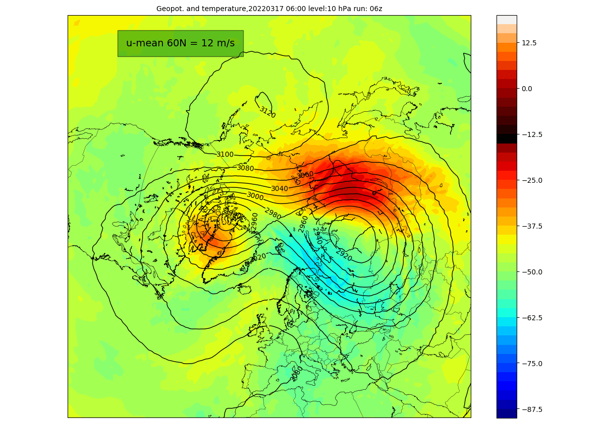
Looking at the current state of the polar vortex, we can see that the vortex is already under pressure from Europe and the North Pacific and is taking on an elliptical shape, and we can see the detachment of the center.
Looking at the temperature at 10 mbar (at an altitude of 30 km), we can see a warming wave developing over eastern Siberia and a weaker wave over northern Canada. Here we can also see the separation of the nucleus into two.
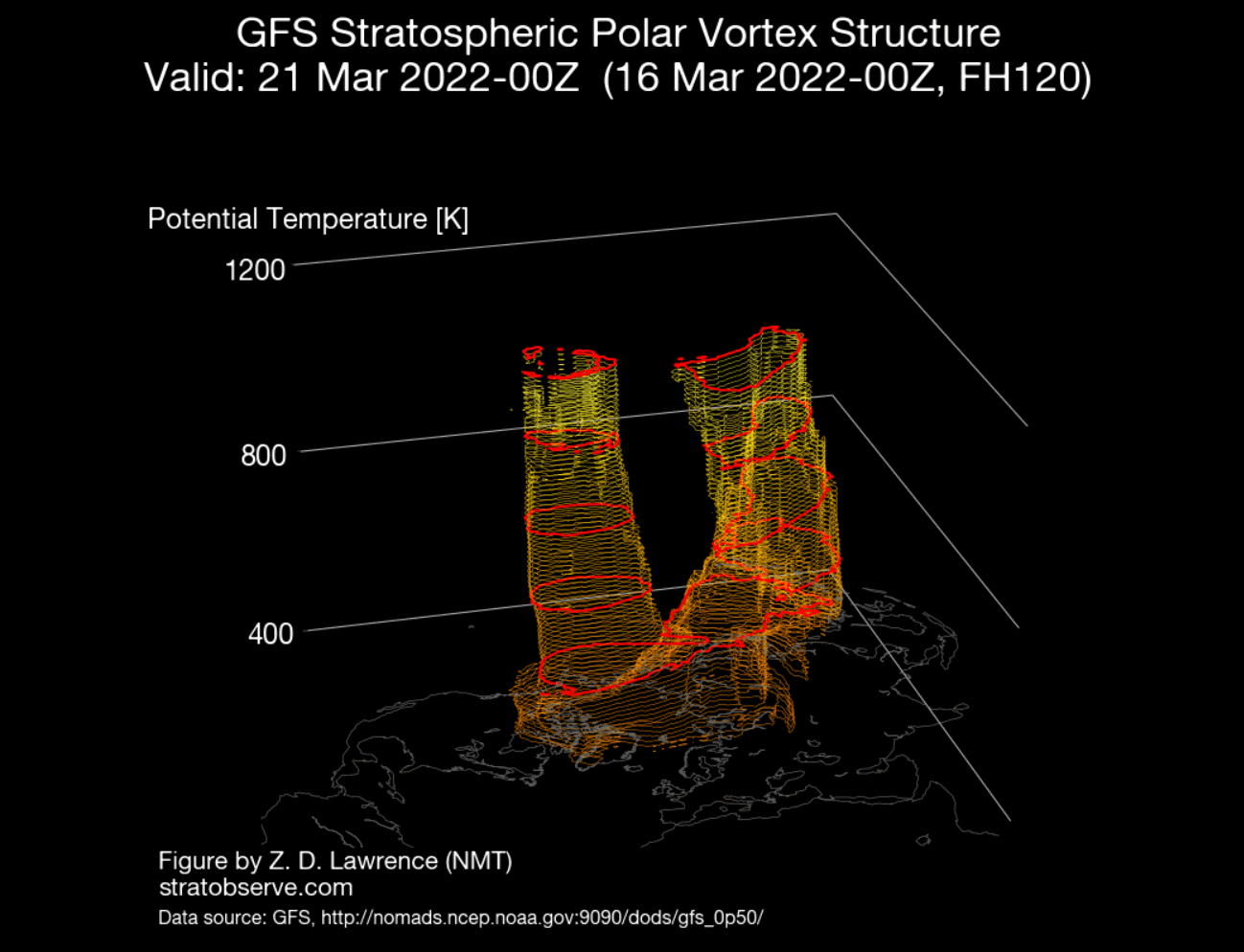
The chapter below can also be seen on the 3D structure of the polar vortex. The vortex has become rectangular, creating two centers. You can imagine this process as squeezing a balloon causing two "bulges" to appear.

The vertical pressure profile reveals a connection between the stratosphere and lower levels. We can see that the regions of low pressure in the stratosphere are already divided into two centers, around which there are two strong regions of high pressure, which put pressure on the polar vortex.
These patterns also determine our current weather, strong pressure will continue to rise over northern Europe, with the low pressure system moving over the southern United States in the coming days. This translates to warmer states in northern Europe under higher pressure, but the lower pressure regime over the southern United States leads to warmer temperatures in the eastern half of the country, and cooler air in the west behind.
The collapse of the stratospheric polar vortex
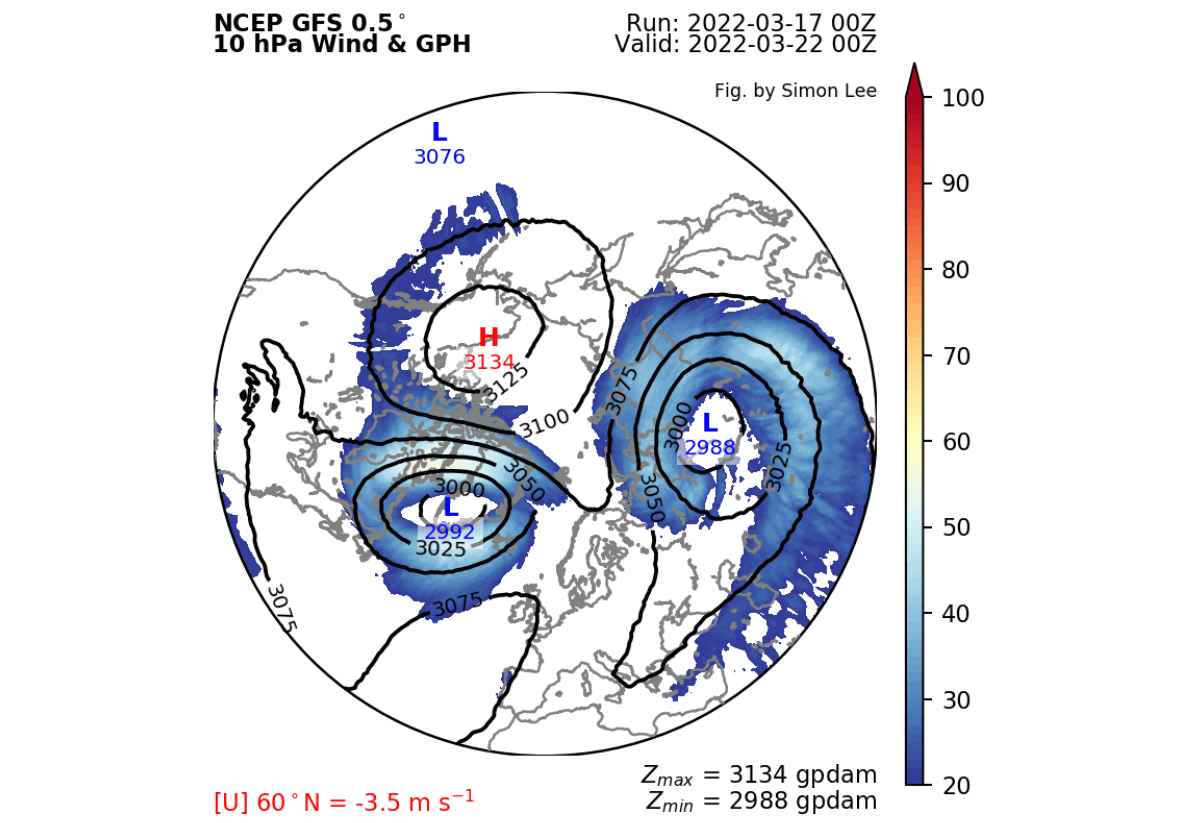
Moving into the late week, we can see strong stratospheric high pressure over North America, completely splitting the polar vortex, the two centers being separated at this point, and the air circulation being reversed.
This is best shown in the projections of the 3D structure below. The polar vortex is clearly separated in all but the lowest levels. The center of the vortex is completely detached and loses energy.
Speaking of lows and weather patterns, we can see in the pressure pattern forecast below, that the major centers are also separated. Rotation still exists around the hemisphere, but the main centers of pressure are separate.
Below we have a wind speed forecast for the atmosphere up to 50 km altitude, we can see strong (negative) easterly winds descending as the polar vortex collapses, this well illustrates the collapse sequence coming from top to bottom. at lower levels.
The collapse of the polar vortex and expectations for the month of April
By the beginning of April, we can see the high pressure system in the stratosphere dominating the entire western hemisphere. The winds are still in the opposite direction, with the remaining weak center of the polar vortex pushing into Siberia.
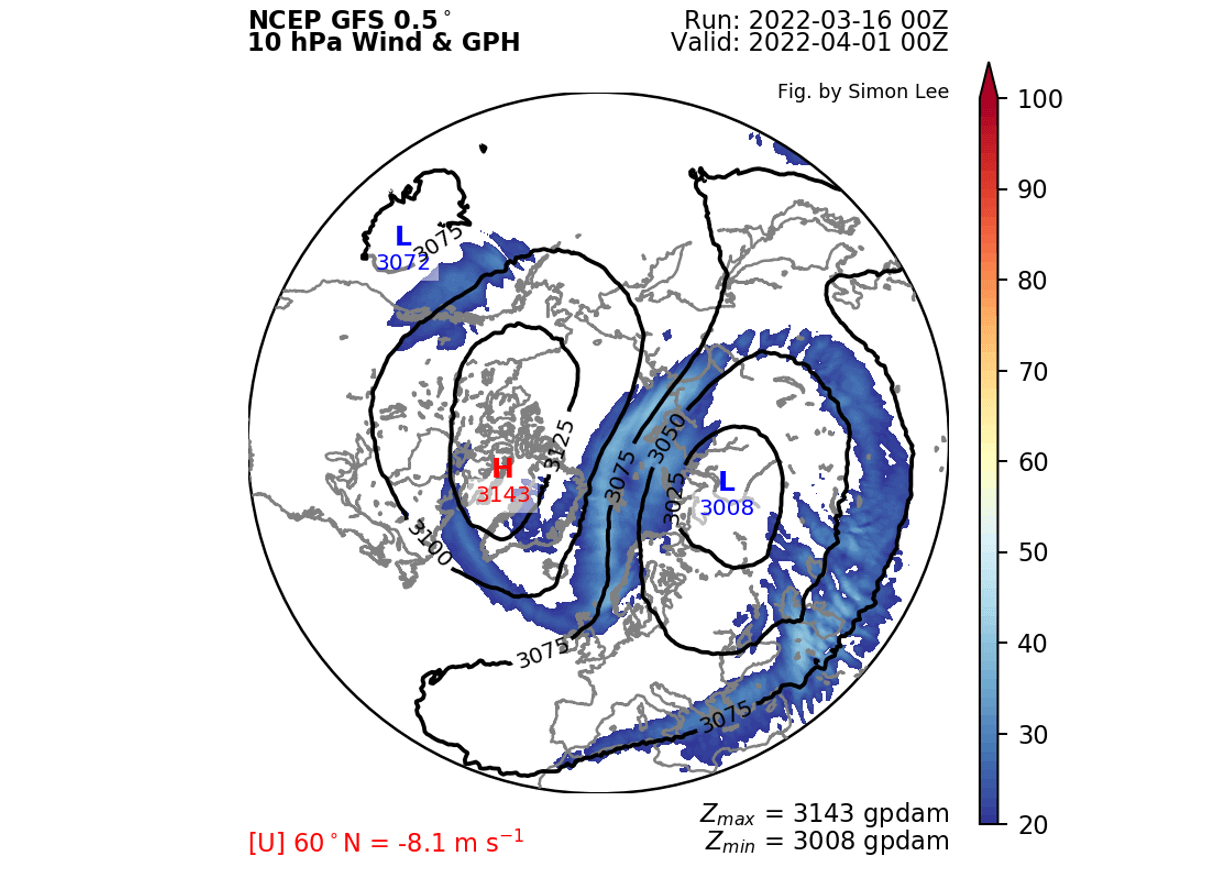
At this time, temperatures are steadily increasing over the North Pole, as the sun returns and gets stronger every day. This means that there is "no way out" for the vortex to remain, as higher temperatures help raise the pressure.
Looking at the temperature at 10 mbar (30 km), we can see that the cold centers are gone, with warming sweeping away the remnants of the polar vortex.

We can see on the 3D structure what is left of the main polar vortex structure. Its remnants are limited to lower levels, with upper air circulation largely collapsing, marking the end of the stratospheric polar vortex until the next cold season begins in the fall.

Looking at the low pressure pattern forecast in early April, we can also see a somewhat fractured lower polar circulation infrastructure. The main core elements focus on northern Europe, eastern Canada, and another low-lying system in the northern Pacific.
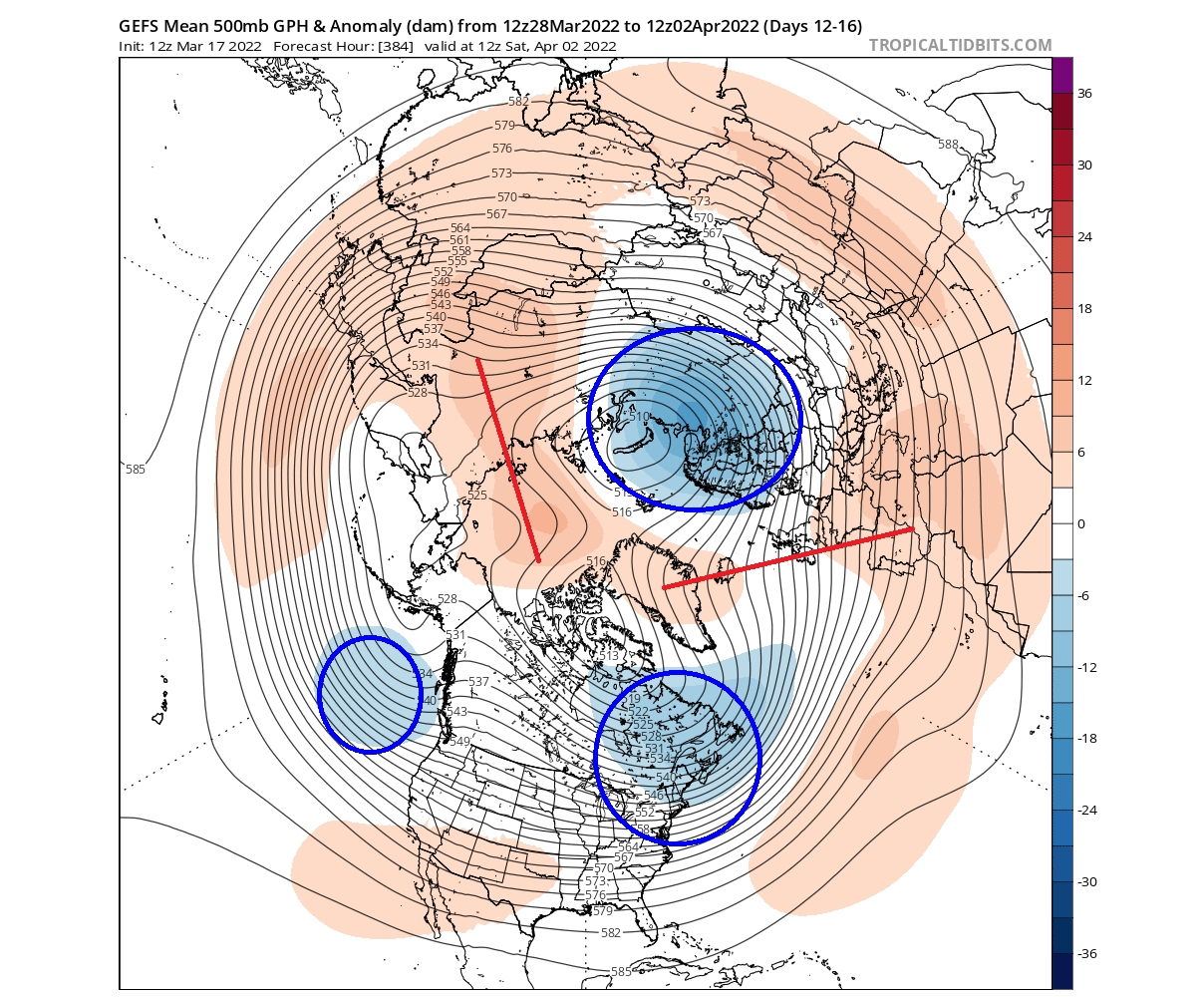
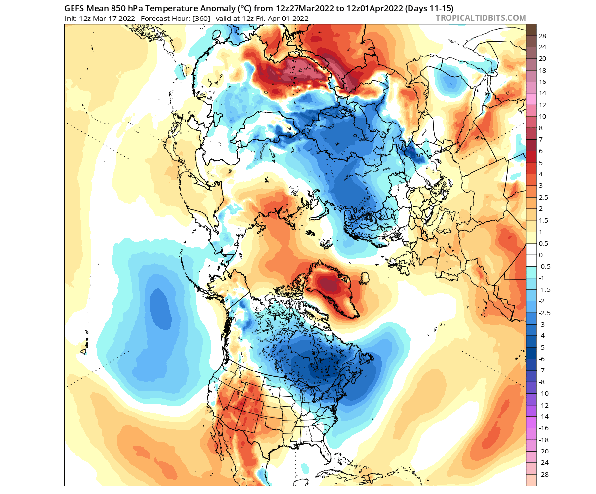
Looking at the temperatures for this period, we can see that the cooler air in the center is in Scandinavia, Siberia, Canada and the northeastern United States, while most of Western and Central Europe and the Middle East are warmer than usual.
Thus, we have clarified the sequence of the collapse of the polar vortex and its impact on changing weather patterns in the northern hemisphere, and Arab Weather will issue forecasts for the upcoming period of April with fuller details through monthly and seasonal bulletins.
Sources: severe-weather.eu


Arabia Weather App
Download the app to receive weather notifications and more..