Sultanate of Oman | Monitoring the formation of an air depression with tropical characteristics in the northeast of the Arabian Sea, and an expected direct impact on the Sultanate, Sunday and Monday

Arab Weather - Specialists in the Arab Regional Weather Center for Meteorology and Forecasting closely follow the latest satellite images and remote sensing observatories, as they indicate the presence of a region of low atmospheric pressure centered to the northeast of the Arabian Sea, and the surface wind speed around the center is estimated at about 17 knots. It is stationed at latitude 21 degrees north and longitude 69 degrees east, about 100 km from the Indian coast (Gujarat), and about 950 km from the coast of the Sultanate (Ras Al Hadd).
According to the future computer simulation of this depression, which is running within the Arab Regional Weather Center, it is expected that the (low atmospheric pressure region) will develop into a tropical depression near the Indian coasts (Gujarat) within the next 24 hours, God willing. The outputs of the computer numerical models for sensing the movement of the air depression vary, so that several scenarios are presented, as some weather models suggest that with the progress of the monsoon winds to the northeast of the Arabian Sea (increasing vertical shear) the occurrence of rotational dispersal of the tropical depression to occur in the upper structure moving away towards the Sultanate, and it may succeed Some of the cumulus clouds accompanying the upper rotation axis at that time by flowing to some governorates in the north of the Sultanate, and the impact would be direct at that time primarily on the governorates of North and South Al Sharqiah, Muscat and Al Dakhiliyah.
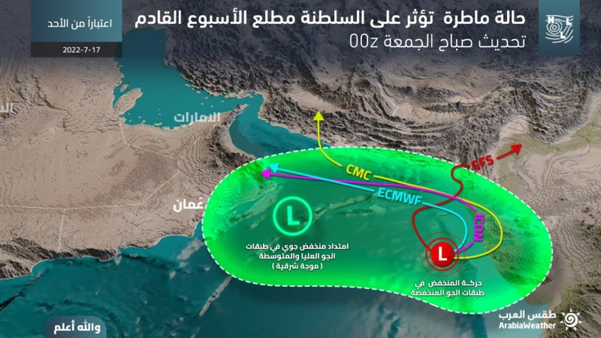
While other numerical models, including the outcomes of a developed system in "Arab Weather", suggest the coherence of the tropical situation as an integrated orbital system, and its movement during the next 48 hours for the Sea of Oman, which leads to rainfall of varying intensity over most of the northern governorates of the Sultanate, including the northern South Al Sharqiah, Muscat, Al Dakhiliyah, Al Dhahirah, North and South Al Batinah, and to a lesser extent, Musandam and Al Wusta. If this scenario is realized, it is feared that torrential rains will form and run quickly, especially in the valleys and reefs. It is possible that sea waves will rise on the coasts of the Sea of Oman, and in conjunction with the high tide level may lead to An extension of sea water over some low-lying coastal areas of the Sea of Oman.
The specialists in the Operations Department at the "Arab Weather" Regional Center for Meteorology and Weather Forecasts periodically review (around the clock) the outputs of the analyzes of weather readings and issue updates/reports if necessary, God willing.


Arabia Weather App
Download the app to receive weather notifications and more..