Thunderstorms observed in some southern and eastern regions, and a warning of the possibility of floods, especially in the desert

2025-03-06 2025-03-06T16:23:30Z
هشام جمال
هشام جمال
كاتب مُحتوى جوّي

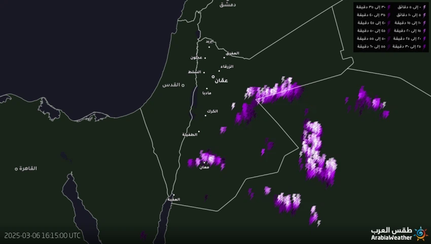
Arab Weather - The latest satellite images from the Arab Weather Regional Center indicate that the southeastern regions and parts of southern Mafraq are affected by cumulonimbus clouds that lead to showers of rain, sometimes heavy and accompanied by hail showers with remarkable activity in the speed of dust-raising winds.

In the rest of the regions, the amount of clouds began to increase, and local showers of rain are likely to fall in scattered and random areas, with expectations of their concentration in the southern parts of the Kingdom. It is not unlikely that the rain will be heavy, leading to the formation of torrents and the flow of valleys and ravines.

God knows best.

This article was written originally in Arabic and is translated using a 3rd party automated service. ArabiaWeather is not responsible for any grammatical errors whatsoever.
See More
Related News
Jordan | Timeline of the low-pressure system that will begin affecting the Kingdom on Monday evening

Jordan | Timeline of the low-pressure system that will begin affecting the Kingdom on Monday evening

Jordan: A second-degree (normal) low-pressure system will begin Monday evening, followed by a very cold air mass at the end of the week.

Jordan: A second-degree (normal) low-pressure system will begin Monday evening, followed by a very cold air mass at the end of the week.

Jordan this week | Getting colder and a new rainy spell is expected!

Jordan this week | Getting colder and a new rainy spell is expected!

Jordan: Cold weather and rain expected in many parts of the Kingdom mid-week (details)

Jordan: Cold weather and rain expected in many parts of the Kingdom mid-week (details)