Under supervision | The chances of the first tropical case in the Arabian Sea increased during the second half of this month

Arab Weather - The weather forecast staff at the Arab Weather Regional Center is observing a relatively high probability of forming a tropical state that is the first this season in the western Indian Ocean and the Arabian Sea with the second half of May 2021, where the coasts of the Sultanate of Oman and Yemen may fall on one of the tracks As the weather in Arabia closely monitors the prevailing weather conditions and the stability of such indicators.
Prevailing weather patterns and conditions
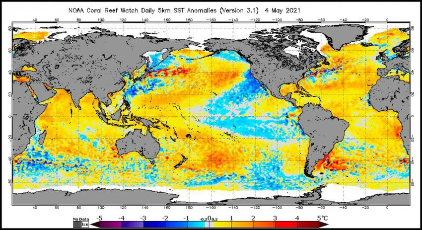
Surface temperature of water bodies
Surface waters in the western Indian Ocean and Arabian Sea are gradually heating up, as they have already started to rise albeit slightly during the past few months, which indirectly contributed to a relative improvement in the chances of rain in parts of the Arabian Peninsula during the spring through tropical interaction with cold air. Coming from the north, and this rise in the water surface in the western half of the Indian Ocean is only a result of the rise of the ( ENSO ) index and the gradual shift of the neutral phase (neutral), as ( ENSO ), in particular, regions 3 and 4 are statistically closely related to the Indian dipole index. ( IOD ).
These weather factors and other factors contribute to crystallizing the formation of the air system on the Arabian Peninsula, God willing, where the weather is the result of an outcome in all weather factors and phenomena represented by several facets of dynamic energy, not a monopoly and a result of a specific weather phenomenon.
Watch also: Muhammad Al Shaker presents the life cycle of hurricanes in a video.
The surface temperatures of the waters of the Arabian Sea and the Indian Ocean are suitable for the formation of hurricanes
In the same context, recorded the degree of the Arabian Sea and the ocean surface temperature of the Indian to the limits of 30-31 ° C, which is ideal to form hurricanes, requiring the presence of a body of water depth of 50 meters and above and the water surface temperature reaches 26.5 ° C and above, in addition to many factors What must be met, especially the absence of the shear winds and its formation away from the equator, because the effective rate of rotation around the local vertical axis is zero at the equator, and we must know that tropical cyclones are generated from the womb of deep depressions, meaning that they are not accompanied by air fronts and derive their energy from the latent warm waters where It develops from the bottom to the top, in contrast to those depressions that form in the middle shows.
An ideal period for the formation of orbital states
A transitional period between monsoon and trade winds
The period during the second half of the month of May / May 2021 is the ideal period to form the orbital situations which may develop into a hurricane sometimes, and attributed this , God willing , to a gradual weakness in the commercial wind movement before the orbital line offers ITCZ and the beginning of blowing southerly winds to Southwesterly or Monsoon is known in early June, which contributes to the absence of vertical shear winds as it leads directly to the weak vertical growth of cumulus clouds.
In this report, we shed light on the most prominent factors responsible for the formation and development of orbital states, and the possibility of the emergence of the first tropical case this season in the western Indian Ocean and the Arabian Sea during the second half of May 2021. Numerical atmospheric models, and we note here that these predictions are preliminary and can be improved or reversed during the next updates.
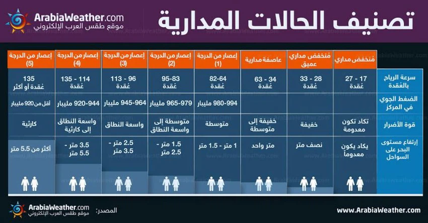
How is the strength of tropical states and hurricanes classified
The " Saphir - Simpson" scale is the basis for classifying the strength of tropical states and hurricanes around the globe, where the wind speed that rotates around the center of the depression is the determinant for the classification of a hurricane or tropical condition, and the figure below shows the classification of the tropical state depending on the wind speed in knots (1 knot = 1.852 km / hr) and the damage range typically involved in each class:


Arabia Weather App
Download the app to receive weather notifications and more..