under surveillance | The increase in the flow of tropical humidity towards the atmosphere of the Sultanate of Oman and the intensification of rain and the intensity of rain again on the first day of Eid Al-Adha

Arab weather - It is expected that the Sultanate, God willing, will remain under the influence of unstable weather conditions during the current week, in conjunction with being affected by a new state of atmospheric instability during the second half of this week that includes large parts of the north of the Sultanate, accompanied by thunderstorms and hail in many from regions.
New weather fluctuations
Rain accompanied by hail showers in the north of the Sultanate
In the details, it is expected that the northern regions of Oman will be directly affected by these weather fluctuations on Tuesday, as a result of a new humid mass rushing into the Sultanate’s atmosphere, accompanied by the presence of large amounts of moisture and high convection in the various active layers of the atmosphere, which leads to the emergence of weather conditions. New unstable conditions, as a result of which amounts of cumulus rain clouds arise over most parts of the Hajar Mountains, especially during the afternoon and evening , and the rains are sometimes heavy and accompanied by showers of hail and thunder as well.
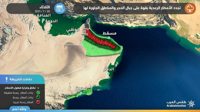
These clouds are expected to extend to the areas adjacent to the Hajar Mountains, especially the eastern and middle stones, including the governorates of Al Dakhiliyah, Al Dhahirah and Al Buraimi, and with the evening hours, some of these clouds are expected to extend towards the coastal areas of the Sea of Oman, including the capital, Muscat. From the rain, it is heavy in some geographical areas, which raises the water level in the roads and may form torrential rains and floods in some areas.
Arab weather indicates that these weather fluctuations require caution against the necessity of fixing flyable holdings due to the intensity of the expected winds, the danger of severe thunderstorms and the accompanying heavy rain, and not to risk cutting valleys and torrents.
In terms of temperature, P At that occurred temperatures rise gradually tend to return to normal levels in the coming days, due to hot weather during daylight hours throughout the interior, while the more moderate in the coastal areas.
Arab Weather advises everyone to follow up on updates to find out what's new about the rainy situation, and we also put in your hands a link to satellite images to follow the development of thunder clouds, moment by moment.


Arabia Weather App
Download the app to receive weather notifications and more..