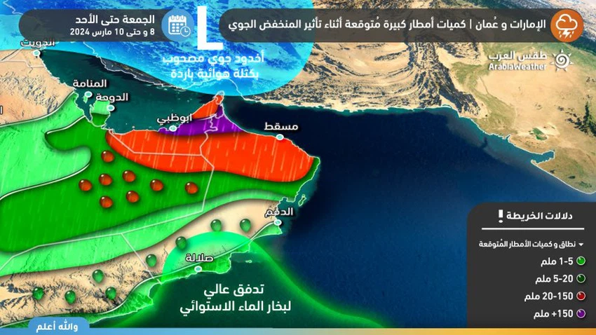
Update 11:00 pm/Alert: The main wave began approaching Oman and the Emirates, and the rain gradually expanded in the late hours of tonight and Saturday.

2024-03-08 2024-03-08T18:59:26Z
محمد عوينة
محمد عوينة
مُتنبئ جوي

From the Arabia Weather Center - the latest satellite images indicate that the main wave accompanying the depression groove has begun approaching the Sultanate of Oman and the Emirates, so that strong cumulonimbus clouds have begun to form in the south of the Emirates and the Empty Quarter desert.

It is expected, God willing, that the main wave will begin to cross in the late hours of tonight and on Saturday, with clouds creeping to the east and intensifying, and heavy to very heavy rains will fall in large parts of the Emirates and the northern governorates of the Sultanate.

The attached map shows the amounts of rain expected during the period of impact of the rainy situation, God Almighty willing.


This article was written originally in Arabic and is translated using a 3rd party automated service. ArabiaWeather is not responsible for any grammatical errors whatsoever.
See More
Related News
Heavy rain accompanied by lightning and hail is expected in several regions of the Arab world during the first week of May.

Heavy rain accompanied by lightning and hail is expected in several regions of the Arab world during the first week of May.

A very cold polar air mass reaches Türkiye, with potential consequences for the region.

A very cold polar air mass reaches Türkiye, with potential consequences for the region.

A regional cold wave will affect eight Arab countries starting Sunday night/Monday morning and continuing until midweek.

A regional cold wave will affect eight Arab countries starting Sunday night/Monday morning and continuing until midweek.

A Khamsin low-pressure system followed by a cold snap necessitates the return of winter clothing in May.

A Khamsin low-pressure system followed by a cold snap necessitates the return of winter clothing in May.