Urgent | Details of the areas covered by the rain forecast and its intensity on Tuesday and Wednesday

Update | Tuesday 20/7/2021 at 2:55 am
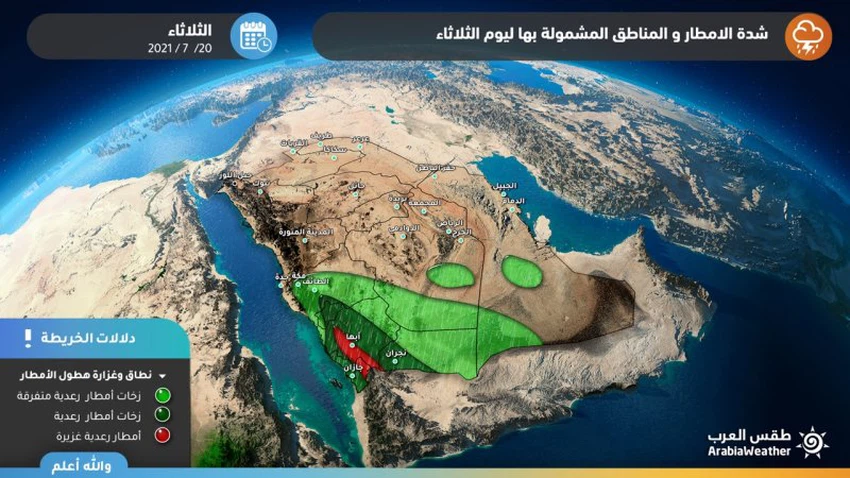
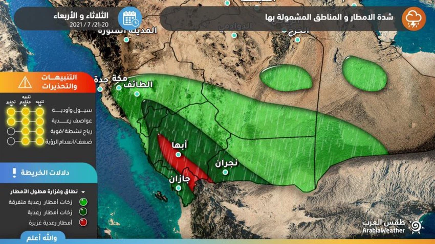
Arab Weather - Sinan Khalaf - The latest output of the computer simulation systems for rain forecasts indicates that many regions of the Kingdom were affected on Tuesday and Wednesday by unstable weather conditions, which are very strong on the southwestern highlands of the Kingdom , and weak to medium in the rest of the regions, and hence the details.
Thunderstorms expected in 7 regions, including Riyadh
Areas covered by rain forecast on Tuesday and Wednesdayأربع
In the details, the current prevailing weather systems and expected in the coming days are still pushing humid air currents towards the region, which means renewed rain opportunities and unstable weather conditions in 7 regions, which are "Jazan - Asir - Al Baha - Taif - Mecca - Riyadh - Eastern."
The nature of this expected weather condition takes on a local character, so that cumulus thunder clouds form randomly in the sky of the capital and its surrounding areas, and some neighborhoods and roads in the city of Riyadh may witness rain, while neighboring neighborhoods and roads are witnessing an atmosphere that is closer to stable.
It is also usually associated with the activity of the descending currents resulting from the activity of cumulus thunderclouds, which in turn may create dust waves from time to time, limiting the horizontal visibility.
Occasionally accompanied by heavy hail
Heavy rain and possible torrential rain in Jizan, Asir and Al Bahah
According to the latest outputs of the numerical models, it is expected that the heights of Jizan and Asir will be strong on Tuesday under the influence of cumulus clouds, and they will increase in intensity further on Wednesday, bringing with them heavy thunderstorms and showers of hail that will be dense and accumulated at times, with a high chance of the formation of torrents. Especially in low-lying areas and mountain slopes, some of these clouds may extend to the areas of Al-Baha and extending to Taif and the eastern parts of the Makkah region, but with less intensity.
Arab Weather advises everyone to follow up on updates to find out all that is new about the developments in the rainy situation, and we also put in your hands these links to follow up on rain radar , and satellite images to follow the development of thunderclouds, moment by moment.
Some important recommendations:
- Alert from the formation of torrents locally in parts of the southwest and west of the Kingdom
- an alert of cold showers that may be accumulated and relatively disruptive to vehicular traffic density
- Warning of the occurrence of thunderstorms and the accompanying activity of dusty surface winds.


Arabia Weather App
Download the app to receive weather notifications and more..