What is the Siberian air altitude

Arabia's weather - the Siberian air rise is a cold continental highland ( Cold Continental Anticyclone ), which is concentrated at 45 degrees north latitude, over northeast Siberia and Central Asia, and it is the largest system of high pressure affecting during the winter of the northern hemisphere.

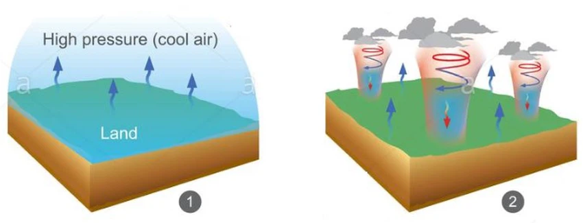
What is the air altitude?
Atmospheric altitude in general is the area at which the surface air pressure rises, where the air pressure rises when it cools, so the cold air is compressed and accumulated over an area, registering a high pressure (Picture 1), or it is formed when the air descends from the top to the bottom, forming a region of separation of air and a pressure area High on the roof (photo 2).
The highest value of pressure is at the center of the atmospheric altitude and the pressure decreases in the direction towards the extremities, and the movement of air from the center towards the sides in a circular motion and clockwise in the northern hemisphere, and counter-clockwise in the southern half, and the air height can cover an area of 320 - 3225 km Square, and the vertical extension is often shallow, with a height of no more than 3000 meters.
What is the Siberian air rise?
The Siberian air rise is known as a huge mass of cold air, which collects over the Siberian region located in northeastern Eurasia, and because the cold air pressure is high, high pressure prevails in the areas it affects, and the temperature drops, where extreme cold and drought are among the most important The characteristics of the Siberian air rise because it is formed as a result of intense surface cooling over continental areas far from marine influences.
The Siberian Highland is responsible for severe and dry cold waves in large areas of Europe and Asia, and its impact may cross the Arctic Ocean to affect Canada and the United States .
The Siberian High Rise was formed
The Siberian atmosphere is caused by the process of radiative cooling of the Earth's surface ( Radiance Cooling ), and contributed to its formation by dry air over the continental region far from marine influences and humidity, as the decrease in temperatures in areas where it is formed to below zero degrees Celsius for several months, causing an increase Atmospheric pressure at its center sometimes reaches 1055 millibars. Cold-dry air is heavy, so the surface air pressure rises despite extreme cold.
Characteristics of the Siberian High Altitude
- The Siberian system is considered one of the most important sources of cold continental air masses, especially the continental polar air masses ( cp ) that push towards the regions that fall at the lowest latitudes (latitudes).
- The occurrences of the Siberian air height are monitored in all seasons of the year except for the summer, in line with the apparent transmission of the movement of the sun, and the south to move north, clearing the way for the seasonal system formed over India.
- The decrease in the land temperature in the winter leads to an increase in the strength of the Siberian Highland, and its extension south to cover the region of Southwest Asia, forming a system of high pressure extending from the plateau of Armenia, Anatolia and northern Iraq.
An arm from the Siberian airspace may penetrate southward to cover the north of the Arabian Peninsula, forming a blocking anticyclone that prevents the advancing of the moving Mediterranean depressions to the east.
- The Siberian high appears at the level of 1000 millibars, and is rarely found at the level of 850 millibars, and disappears completely at the levels of 500 and 700 millibars, because at this altitude the air mass is cold and heavy, so it does not reach the upper atmosphere only rarely.
-
Monthly and annual frequency of the Siberian high
The actual period or season of the Siberian high repetition extends between the months of December until the month of March, as the month of September marks the beginning of the emergence of the Siberian Highland coinciding with the apparent perpendicularity of the sun to the equator, and the beginning of its departure towards the south, and the further the sun moves towards the south the greater Its repetitions and duration of stay, that is, it intensifies and expands in the winter, and the month of March represents the actual end of the effects of the Siberian high, and the transfer of its effects to the north, until there are no repetitions during the summer months, and its repetition is consistent with the presence of a large number of pressure systems, but it forms an air barrier on the one hand The east prevents the systems moving to the east from penetrating.
Types of winds accompanying the Siberian high
1. Static winds : They are winds that do not have a clear horizontal direction that can be distinguished and measured, and their velocity ranges between 0 - 0.2 m / s. Atmospheric heights are considered one of the most important systems that are characterized by stable states, where the winds tend to remain still after the fall of air currents and dispersal It has near the surface of the earth, and this may happen more in the cold air heights, because the cold air is ineligible for height due to its heaviness and high density, so it tends to be static, so the Siberian air height is associated with frequent static states compared to other types of air heights.
2. The northern winds : these are the winds that blow from the north towards the south. The movement of the Siberian air altitude may be accompanied by northerly winds. Repeated cases of the northern winds were recorded in the monitoring stations when the Siberian high prevails over its airspace, and the northern winds occupied the third order in the directions of the winds accompanying the Siberian high. The northern winds are associated with the Siberian Highland when it extends in a broad arm and connects to the European and subtropical high elevation, which contributes to modifying the associated air mass.
3. Northeastern winds: This type of wind is the most frequent type of wind associated with the Siberian high, and it can be considered the prevailing wind accompanying it, and thus it takes the first place among all pressure systems that cause winds to blow from this direction, and the reason for the high frequency of this is related The winds refer to the anticyclone nature of the Siberian highland that corresponds to the movement of the clock, the general movement from east to west and southwest, in addition to the terrain that contributes to determining its general paths and the movement of the accompanying winds.
4. Eastern winds: the eastern winds come in second place among the types of winds accompanying the Siberian high. There may be spatial variations that control the eastern winds so that their frequency increases on the sites near the east than the regions to the west.
5 . Southeastern winds: These winds represent the least frequent types of winds that are associated with the Siberian high, and the Siberian airwheel is the only high atmosphere that contributes to the southeast winds.


Arabia Weather App
Download the app to receive weather notifications and more..